Tianyi Sensor IOT Technology Co., Ltd
Sales Manager:Ms. Emily Wang
Cel,Whatsapp,Wechat:+86 15898932201
Email:info@fengtutec.com
Add:No. 155 Optoelectronic Industry Accelerator, Gaoxin District, Weifang, Shandong, China


Sales Manager:Ms. Emily Wang
Cel,Whatsapp,Wechat:+86 15898932201
Email:info@fengtutec.com
Add:No. 155 Optoelectronic Industry Accelerator, Gaoxin District, Weifang, Shandong, China
Model:FT-CS80
Brand:tianyi
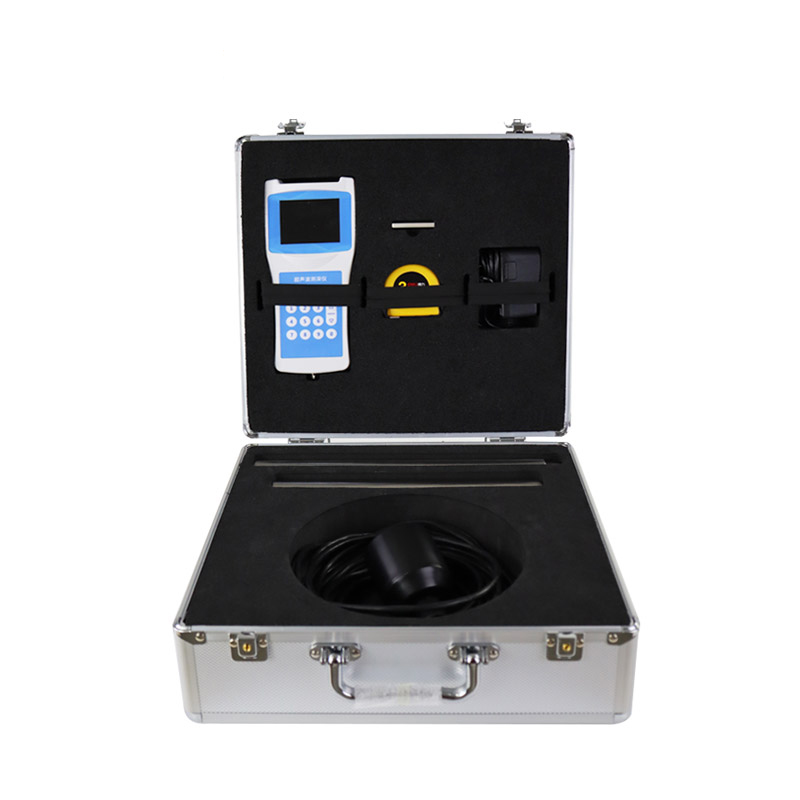
1.Introduction to Handheld Depth Finder Products
Handheld Depth Finder provides instant depth readings from 0-80 meters, use them in a kayak or canoe for instant depth measurements.Handheld Depth Finder is a Handheld Depth Finder that measures water bodies such as reservoirs, lakes, rivers, shallow seas, etc.When the depth is measured, the ultrasonic transducer is placed on the water surface or a certain position.The fixed sound speed of ultrasonic waves in the water and the time T emitted by ultrasonic waves to the reception time T, and the instrument automatically converts the water depth H.This product is a convenient and suitable handheld ultrasonic distance measuring instrument developed by our company for many years of production experience, absorbing the advantages of many similar products.The ultrasonic transceiver and reception conversion circuit adopts a dedicated large-scale integrated circuit with a component patch rate of 99%, and the depth of the liquid crystal displays, ensuring the long-term reliability of the product and reducing its power consumption to an extremely low level.It has the advantages of accurate measurement, power consumption, high reliability, easy use, simple operation, accurate measurement speed, and easy portability.The instrument can be measured in still water or in water with a certain speed; the water flow rate can reach about 5m/second, making it an ideal water depth measurement instrument for hydrological testing, hydropower plant reservoir area, lakes, river channel surveys and environmental water monitoring.
2.Technical features of Handheld Depth Finder
Medium, small ship is installed outboard (inside) with cables of 10 meters;
Static fixed-point measurement;
Self-stable measurement technology and fast tracking technology, real-time response to real measurement results;
Built-in watchdog circuit to ensure reliable and stable operation for a long time;
Large capacity storage, using USB flash drive to export data;
High-precision clock, annual error of 3PPM;
The FAT32 file system automatically exports and stores it as a CSV format file;
The high-bright screen display is used to display the field measurement data more clearly;
3.Handheld Depth Finder Technical Parameters
| Measurement principle | Ultrasonic measurement method |
| Range range | 0-80 meters |
| Blind area | 0.5 meters |
| power | Transmission power level 32, automatic gain adjustment |
| Minimum display resolution | 0.1mm |
| Accuracy | ±1%×range |
| show | Chinese LCD full color screen display |
| Operating frequency | 200~2000KHz |
| On-site settings: | Completed by sensor key |
| Calibration: | Factory calibration, on-site calibration |
| Output, storage | Export data from USB disk, and the on-board FLASH generates EXCEL files to automatically store the measurement data, with a maximum storage number of 5,000 pieces. |
| Operating voltage: | Built-in battery, external charger |
| keyboard: | Number keys |
| Material: | Host: ABS engineering plastics |
| Sensor: ABS engineering plastic | |
| Test rod: stainless steel, 2 pieces | |
| weight: | Host: 300g |
| Sensor: 650~750g | |
| Sensor cable: | Wire diameter 5~10mm×10m |
| Sensor weight tube: | Length 53cm |
| Temperature measurement range: | -45℃~85℃ |
| Operating temperature: | ≤80%RH without condensation |
| Storage temperature: | ≤80%RH without condensation -40℃~70℃ |
Agricultural monitoring system provides precise guidance for agricultural production through comprehensive monitoring of soil moisture, crop growth, pest and disease infestations, and disasters.Soil Moisture Monitoring focuses on soil water status. Imbalances in soil moisture directly affect crop gr...
The core advantage of the Wireless Weather Station lies in its integrated composite meteorological sensor. This key component can accurately measure various meteorological parameters, effectively meeting application needs in different scenarios and providing reliable support for obtaining meteorolog...
Life Detector Device is a vital sign detection device based on ultra-wideband radar technology. It can penetrate non-metallic obstacles such as brick walls and rubble, detecting stationary life forms at a distance of ≥26 meters and moving life forms at a distance of ≥36 meters. It features t...
Life Detector Device system integrates ultra-wideband radar technology and biomedical engineering technology. It uses the Doppler effect generated by human breathing and heartbeat to penetrate rubble and search for survivors, with a detection range of up to 30 meters. It is widely used in disa...


 Get a Free Quote
 Skype
Skype
 whatsapp
 mail
mail