Tianyi Sensor IOT Technology Co., Ltd
Sales Manager:Ms. Emily Wang
Cel,Whatsapp,Wechat:+86 15898932201
Email:info@fengtutec.com
Add:No. 155 Optoelectronic Industry Accelerator, Gaoxin District, Weifang, Shandong, China


Sales Manager:Ms. Emily Wang
Cel,Whatsapp,Wechat:+86 15898932201
Email:info@fengtutec.com
Add:No. 155 Optoelectronic Industry Accelerator, Gaoxin District, Weifang, Shandong, China
Model:FT-LMZK2
Brand:tianyi
1.Road Surface Condition product introduction
Road Surface Condition is a non-intrusive road condition sensor that measures the thickness and slipperiness of road water, ice and snow.Road Surface Condition uses remote sensing technology to avoid damage to the road and thus avoid traffic interference caused by the installation of road weather stations.
Under road conditions where embedded pavement sensors are inconvenient or cannot be installed, remote sensing installation means that there is no need to close the road or cut the pavement, and the installation work is both safe and convenient.Low maintenance is an ideal choice for road meteorological systems.
It can be installed on existing weather stations or on other buildings with unobstructed views of the road surface.
Multi-spectral measurement technology enables accurate detection of the thickness of icy, snow and water on the surface of the road.
By providing road surface condition information, road management departments provide accurate monitoring data and take response measures before road safety risks occur.
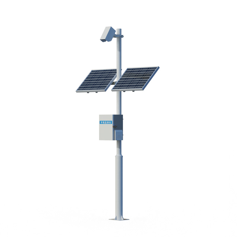
2.Road Surface Condition system composition: road condition sensor, collector, pole bracket, power supply system, cloud platform
3.Road Surface Condition product application
1.Install the bridge surface from a long distance
2.Areas with frequent accidents
3.Areas with large traffic flow
3.Areas with frequent rain and snow
4.Road Surface Condition product features
1.Long-distance measurement of road area water, ice and snow
2.Measure the road surface status
3.Measure the degree of water accumulation, ice surface, and slipperyness
4.Non-buried design
5.Resistant to rust
6.Infrared detection up to 15 meters
7.No need to close the lane, easy installation and maintenance
8.Rustrated design, all-weather measurement
5.Road Surface Condition Technical Parameters
| Monitoring distance | 2-15 meters | ||
| Detection diameter | 23cm | ||
| angle | 30-90 degrees | ||
| Power input | 220VAC, 24VDC | ||
| Maximum power consumption | 5W (including lens heating) | ||
| Operating temperature | -38ºC to +70ºC | ||
| Working humidity | Degree 0 to 100% | ||
| Road state parameter output | Road area water thickness: 0.00-10mm | Resolution: 0.01mm | Accuracy: 0.1mm |
| Pavement ice thickness: 0.00-10mm | |||
| Road area snow thickness: 0.00-10mm | |||
| The degree of slippery road surface: 0.00-1 | Resolution: 0.01 | ||
| (*) Pavement temperature: -38ºC to +60ºC | |||
| (*) Pavement humidity: 0-100% | |||
| (*) Ambient temperature and humidity: -40ºC to +70ºC | |||
| (*) Atmospheric pressure: 150-1100hPa | |||
| Pavement status report | Dry, damp, wet, snow, ice, ice water mixed (*frost) | ||
| Lens pollution detection | Pollution level measurement of optical lenses and internal automatic pollution compensation | ||
| Pavement materials | Concrete and asphalt pavement | ||
| communication | RS485, RS232 | ||
| Average no trouble | 10 years | ||
| Safety | No safety issues – infrared remote sensing measurement technology | ||
Here's a little bit of knowledge: Bridges actually freeze more easily than road surfaces.Why is that?From the perspective of heat dissipation, the temperature difference between a bridge deck and an ordinary road surface is quite understandable. The road surface is directly built on the ground,...
In today's intertwined context of agricultural modernization and ecological conservation needs, dynamic changes in soil moisture directly impact crop growth, water resource utilization, and ecosystem stability. Automatic Soil Monitoring Systems are becoming the link connecting farmland managemen...
Meteorological monitoring system is a high-precision automatic meteorological observation device integrating temperature, humidity, wind speed, wind direction, and atmospheric pressure sensors. This device combines ultrasonic detection technology to achieve accurate all-weather monitoring of meteorological elements....
Life Detector Device integrates infrared thermal imaging detection, 4K high-definition video observation, and two-way voice communication functions. This device can effectively locate signs of life in complex environments such as debris and enable communication between rescuers and those trapp...


 Get a Free Quote
 Skype
Skype
 whatsapp
 mail
mail