Tianyi Sensor IOT Technology Co., Ltd
Sales Manager:Ms. Emily Wang
Cel,Whatsapp,Wechat:+86 15898932201
Email:info@fengtutec.com
Add:No. 155 Optoelectronic Industry Accelerator, Gaoxin District, Weifang, Shandong, China


Sales Manager:Ms. Emily Wang
Cel,Whatsapp,Wechat:+86 15898932201
Email:info@fengtutec.com
Add:No. 155 Optoelectronic Industry Accelerator, Gaoxin District, Weifang, Shandong, China
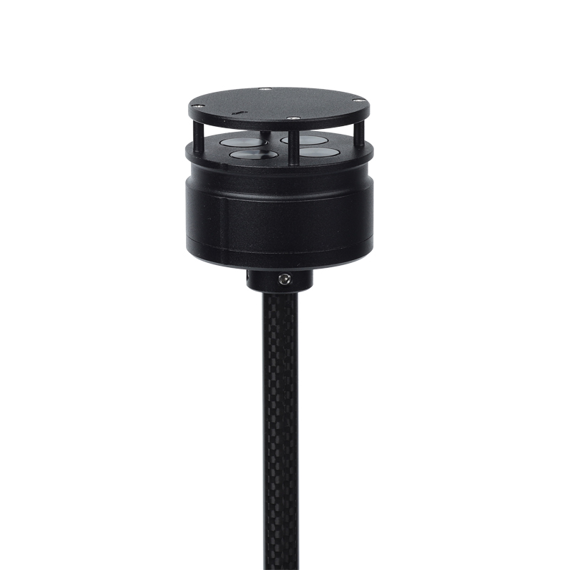
Model:FT-F1
Brand:tianyi
Product Name: Anemometer for drones
Anemometer for drones is a compact ultrasonic anemometer that can be carried by drones and can accurately measure wind speed and direction.
Product Introduction: F1 Anemometer for drones is a wind speed and direction meter that utilizes the principle of ultrasonic resonance.
It is specially designed to be installed on small aircraft and on unmanned platforms to monitor wind speed and direction values in low-altitude areas.
The weight of F1 is 56g, the diameter is 46mm, the size is small and the weight is light. It has a compact and solid appearance, and has extremely strong anti-electromagnetic interference, waterproof and dustproof functions. It can work normally at an altitude of 4,000 meters and the external environment between -40°C and +70°C.
It uses low-power chips internally, and can measure wind up to 60m/s, especially for unmanned aircraft and related flight control platforms, as well as environmental monitoring systems using aircraft.
F1 has two installation methods, which can be mounted on the top of the aircraft and can be mounted upside down on the bottom of the aircraft.
Anemometer for drones technical indicators:
Wind speed measurement range 0-60m/s, accuracy 3%, resolution 0.1m/s
Wind direction measurement range 0-359°, accuracy ±3°, resolution 1°
Instrument diameter 46mm
Instrument height 48mm
Instrument weight 56g
Material ABS
Color black
Digital output RS485
Baud rate 4800-19200
Communication protocol ModBus, ASCII
Operating temperature/humidity -40℃-+70℃; 0-100%
Working altitude 0-4000 meters
Power supply requirements VDC: 5-30V; 15mA (12V)
Installation method: Top column installation or bottom lifting of aircraft
Soil salinity refers to the total amount of various soluble salts contained in the soil. Imagine that the soil is like a large container filled with a variety of substances, and soil salinity is one of these substances. These salts mainly accumulate gradually during the soil formation process from s...
Negative oxygen ion monitoring plays a crucial role in ecological environment research and air quality management. Negative oxygen ions are negatively charged ions in the air, which are widely distributed in the natural environment. Their concentration levels are closely related to air quality. High...
Shandong Fengtu, based on sensor and BeiDou positioning technology, utilizes differential RTK technology to achieve millimeter-level displacement monitoring. It can conduct monitoring for various engineering projects, including dams, bridges, and slopes. Shandong Fengtu spec...
The cost of water level monitoring equipment varies based on brand, model, functionality, and measurement precision. Buried-type water level monitoring devices are priced at approximately 4,000 yuan; submersible devices are around 6,000 yuan; and river channel water level monitoring stations c...


 Get a Free Quote
 Skype
Skype
 whatsapp
 mail
mail