Tianyi Sensor IOT Technology Co., Ltd
Sales Manager:Ms. Emily Wang
Cel,Whatsapp,Wechat:+86 15898932201
Email:info@fengtutec.com
Add:No. 155 Optoelectronic Industry Accelerator, Gaoxin District, Weifang, Shandong, China


Sales Manager:Ms. Emily Wang
Cel,Whatsapp,Wechat:+86 15898932201
Email:info@fengtutec.com
Add:No. 155 Optoelectronic Industry Accelerator, Gaoxin District, Weifang, Shandong, China
time:2025-06-18 08:52:18 source:Weather Station viewed:392 time
Measuring river water levels is necessary for flood control and disaster reduction. Through real-time monitoring of river water levels, we can timely grasp the changes in water levels, issue warnings before floods arrive, strive for time for personnel evacuation and property transfer, and minimize the losses caused by flood disasters.
So how to measure it?
At present, radar and ultrasonic are two commonly used methods for measuring river water levels.
The ultrasonic water level meter works by transmitting ultrasonic pulses to the water surface, calculating the distance from the sensor to the water surface based on the time difference between transmission and reception and the propagation speed of ultrasonic waves in the air, so as to determine the water level height. It is suitable for calm and non-corrosive water bodies, such as small agricultural irrigation ponds, urban landscape lakes and other scenarios with not particularly high requirements for accuracy and requiring low-cost solutions. However, its accuracy is generally between ±1% and ±3%, and it is greatly affected by environmental factors such as temperature, humidity and wind speed.
The radar water level meter uses the reflection principle of electromagnetic waves (radar waves), and also calculates the distance from the sensor to the water surface according to the time difference between transmission and reception and the propagation speed to determine the water level. It can adapt to complex environments and perform well in industrial fields, large-scale water conservancy projects and harsh environments, such as river estuaries, sewage treatment plants, reservoir liquid level monitoring, etc. The radar water level meter has relatively high accuracy, up to ±5mm, strong anti-interference ability, is not affected by temperature, humidity, wind speed and other factors, and also has good resistance to interference such as steam and dust.
Through comprehensive comparison, the radar water level meter has more obvious advantages in river water level monitoring.
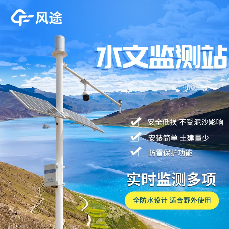
Water Level Monitoring System Based on Radar —— FT-SW1
FT-SW1 is an instrument dedicated to water level monitoring, which uses 24GHz radio frequency radar technology, with high precision and good stability. The measurement range can reach 40 meters, which can meet the water level monitoring needs of most rivers. The device adopts a non-contact measurement method, is not affected by water quality, and is not disturbed by factors such as water flow velocity and color, and can work for a long time in harsh environments.
In terms of system composition, in addition to the radar water level meter, it also includes a data collection and transmission module, a data processing and analysis platform, etc. The data collection and transmission module is responsible for collecting the water level data measured by the radar water level meter and transmitting the data to the data processing and analysis platform through wireless communication technologies such as GPRS and 4G. The platform stores, sorts out and analyzes the received data to realize the functions of real-time monitoring and early warning of water levels. Users can remotely access the platform through terminal devices such as computers or mobile phones to view the river water level information in real time. When the water level exceeds the set safe range, the system will automatically issue an early warning notice.
Miniature rain gauge is a device that uses a PVDF piezoelectric film as the core rain-sensing component and integrates an embedded AI neural network algorithm to distinguish raindrop signals. It can remotely measure precipitation, precipitation intensity, and the start and end times of rainfall, achieving real-time and accurate measurement. It is widely used in meteorological monitoring and agricultural irrigation....
Meteorological monitoring equipment includes six-parameter automatic weather stations, precipitation sensors, radiation observation stations, and unmanned aerial vehicle (UAV) systems, used to monitor meteorological elements such as temperature, humidity, wind speed and direction, rainfall, at...
The FT-WQX8B Photovoltaic Weather Station is a professional environmental monitoring device developed and manufactured by Fengtu Technology, a company specializing in the R&D of micro weather stations and meteorological environment solutions. With a complete industrial chain and technical team,...
To meet the needs of air pollution prevention and control, environmental protection authorities require more refined and efficient air quality supervision. However, traditional national standard monitoring stations, despite providing high data accuracy, face limitations such as high construction cos...


 Skype
Skype
 whatsapp
 mail
mail