Tianyi Sensor IOT Technology Co., Ltd
Sales Manager:Ms. Emily Wang
Cel,Whatsapp,Wechat:+86 15898932201
Email:info@fengtutec.com
Add:No. 155 Optoelectronic Industry Accelerator, Gaoxin District, Weifang, Shandong, China


Sales Manager:Ms. Emily Wang
Cel,Whatsapp,Wechat:+86 15898932201
Email:info@fengtutec.com
Add:No. 155 Optoelectronic Industry Accelerator, Gaoxin District, Weifang, Shandong, China
time:2025-12-12 11:12:19 source:Weather Station viewed:389 time
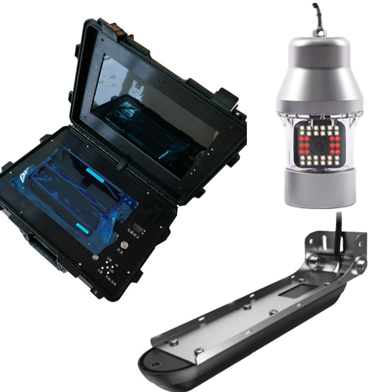
Underwater sonar imaging sounder is a portable underwater detection device integrating sonar technology and video recording. It generates high-resolution underwater topographic images, 3D models, and target location information by emitting sound waves into the water and receiving the echoes. It is suitable for single-person outdoor operations such as underwater search and rescue, topographic mapping, and engineering surveys.
The core working principle of Underwater sonar imaging sounder is based on the emission, reflection, and reception of sound waves. The device converts electrical energy into sound wave pulses of a specific frequency and emits them underwater. The sound waves are reflected when they encounter riverbeds, rocks, submerged objects, or water boundaries during propagation. The device's sophisticated receiver captures these reflected echoes and calculates the target distance by measuring the round-trip time of the sound waves. Combined with sound wave intensity information, the device is reconstructed using internal processor algorithms, ultimately forming a visualized underwater topographic profile, 2D scan image, or 3D model on the display terminal. Some models integrate an auxiliary underwater camera unit, which can provide optical video confirmation after initial sonar positioning, enabling collaborative operation of "acoustic positioning and optical verification."
The core functional characteristics of this device are its high resolution and portability. High resolution means it can clearly distinguish subtle underwater topographic changes and small objects, producing rich image details. Portability is reflected in the equipment's typically integrated or lightweight modular design, making it lightweight and easily deployable by a single person at docks, shorelines, or small boats. The user interface is often simplified, allowing users to complete the entire process of equipment assembly, parameter setting, data acquisition, and result preview after basic training, greatly improving efficiency in fieldwork.
In practical applications, Underwater sonar imaging sounder primarily serves several specific fields. In underwater search and rescue and salvage, rescuers can use it to quickly scan accident areas, map riverbed topography, and accurately locate drowning victims, sunken vehicles, or other key targets, providing a visual view for developing salvage plans. In hydrological surveying and water conservancy engineering, it can be used to measure the underwater topography of reservoirs, rivers, and ports, calculate siltation, and assess bank stability. Before infrastructure construction, it assists in underwater geological surveys for bridge pier site selection and pipeline routing. Furthermore, it is also used in specialized scenarios such as aquaculture cage monitoring and underwater archaeological site exploration.
Effective use of this equipment requires attention to its technical limitations and environmental adaptability. The propagation speed and effectiveness of sound waves are affected by water temperature, salinity, water depth, and suspended solids content; parameter calibration is necessary in complex water environments. Its detection accuracy and range are a trade-off: high-frequency sonar offers high resolution but has a short operating range, while low-frequency sonar has a longer detection range but relatively lower resolution; the appropriate equipment model or operating frequency must be selected based on the mission objectives. Acquired data typically requires further processing, analysis, and interpretation in specialized software to generate standardized mapping results or analysis reports.
Currently, the technological development of Underwater sonar imaging sounder is evolving towards greater intelligence and integration. New equipment increasingly integrates high-precision GPS/BeiDou positioning, inertial measurement units, and real-time wireless data transmission, enabling precise spatial positioning of the detection trajectory and remote real-time data viewing. With advancements in algorithms, automatic target recognition and classification functions are also emerging. As a portable tool replacing traditional, cumbersome underwater mapping methods, this equipment significantly reduces the technical barriers and costs of underwater exploration, providing efficient and intuitive technical solutions for various tasks in the water-related industry.
In the efforts to tackle air pollution, the precise identification of pollution sources is a core prerequisite for formulating effective response measures. Traditional manual analysis is time-consuming and susceptible to interference from various external factors, leading to deviations in pollution...
In today's fast-paced life, people are paying increasing attention to health. Taking leisure vacations at scenic spots has become the first choice for many to relax their minds and bodies and get close to nature. And negative oxygen ions, an invisible yet significant substance in scenic spots, a...
Negative oxygen ion monitoring stations collect real - time data on negative oxygen ion concentrations in the environment through sensors, and transmit the data to the background for processing and display via communication technologies. The core of this system lies in its precise perception of the...
The integrated weather station is a highly integrated, low-power, and quickly installable high-precision automatic meteorological observation device. It employs a twelve-element integrated sensor to monitor meteorological elements such as wind speed, wind direction, temperature, humidity, air...


 Skype
Skype
 whatsapp
 mail
mail