Tianyi Sensor IOT Technology Co., Ltd
Sales Manager:Ms. Emily Wang
Cel,Whatsapp,Wechat:+86 15898932201
Email:info@fengtutec.com
Add:No. 155 Optoelectronic Industry Accelerator, Gaoxin District, Weifang, Shandong, China


Sales Manager:Ms. Emily Wang
Cel,Whatsapp,Wechat:+86 15898932201
Email:info@fengtutec.com
Add:No. 155 Optoelectronic Industry Accelerator, Gaoxin District, Weifang, Shandong, China
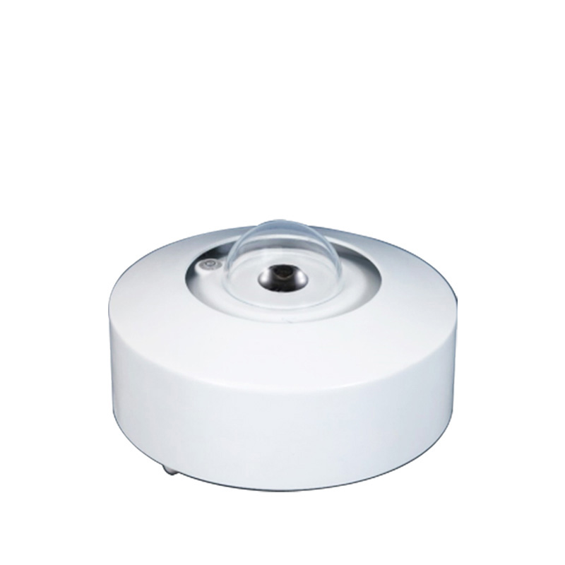
Model:FT-TK1S
Brand:tianyi
1.Automatic Total Sky Imager product overview
Automatic Total Sky Imager provides real-time digital sky images of daytime sky conditions and calculates the percentage of cloud cover in the sky.Automatic Total Sky Imager uses high-precision fisheye lenses to automatically record cloud-like distribution throughout the sky without sun occlusion device and direct sunlight, saving pictures of cloud distribution in the sky.The protective glass uses a hard coated dome to protect the lens from the weather and prevent sun exposure from damage to the CCD measuring element.
The equipment is simple to install and fully modularly installed.The equipment can adopt ventilation and heating devices, so that the imaging device will not be affected by weather changes.Analyze clear sky, hemisphere cloud cover, thick and thin clouds, artificial horizons covered by the horizon and cloud cover above the cloud cover.
The cloud bottom height software provides possibilities, and the cloud altitude and data (latitude, longitude and altitude) are evaluated in real time on site and stored with each individual CMS image.This product has dynamic analysis function, which can clearly record the distribution of cloud shape and cloud volume in the sky during the day, and automatically save it to the local machine for comparison and analysis, or upload it to the cloud to identify the cloud information through AI algorithms.It can be widely used in meteorology, civil aviation, transportation, marine research, smart cities and other fields.
The imager has a wide viewing angle of 175° and a high-resolution sensor, which can automatically record cloud conditions throughout the sky and convert it into quantitative cloud information through advanced cloud detection algorithms in the software.The imager can access the Internet through a standard network card and transmit data to a server or a monitoring computer through the network.
The imager control software integrates a horizon determination tool, providing users with flexibility and functional needs.For example, the software can set the zenith angle range, the ground object shielding area or the area of interest to avoid the impact of inherent masks around the station on the observation results.The imager also has good waterproofing.
2.Automatic Total Sky Imager product features
15 million pixel fisheye camera, real-time image acquisition
2.External TRH sensor
3.Maximum output of 2560×1920 30fps images
4.No sun blocking device, effectively record the cloud conditions in the sky
5.Built-in computer host, no additional workstation installation required
6.It can connect to the network, and can access multiple cloud platforms through remote operation and monitoring of terminals.
7.Low power consumption, small size, light weight, easy to install outdoor
8.It has waterproof function, can be used for all-weather observation
3.Technical parameters of Automatic Total Sky Imager
| Technical parameters | Measurement range |
| Sensor technology | 5 million pixels, high-quality CMOS photosensitive module |
| Operational requirements | Work all day |
| Visible pixels | ≥1 million |
| Detect wavelength | 8~14μm |
| Use resolution | 50Hz: 25fps (2560×1920, 2048×1536, 1280×960) 60Hz: 30fps (2560×1920, 2048×1536, 1280×960) |
| Lens type | Fisheye prime lens |
| Field of view FOV | Horizontal field of view: 180°, vertical field of view: 180° |
| Storage function | Support Micro SD/SDHC/SDXC card (128G) to disconnect local storage, NAS (NFS, SMB/CIFS both support) |
| Interface protocol | ONVIF (PROFILES, PROFILEG), PSIA, CGI, ISAPI |
| Network protocol | TCP/IP, UDP, ARP, ICMP, HTTP, HTTPS, FTP, DHCP, DNS, DDNS, RTP, RTSP, RTCP, PPPoE, NTP, UPnP, SMTP, SNMP, IGMP, 802.1X, QoS, IPv6, Bonjour |
| Communication interface | Ethernet RJ45, wireless network WIFI |
| Safe Mode | 64/128-bit WEP, WPA/WPA2, WPA-PSK/WPA2-PSK, WPS |
| File upload | Jpg images can be uploaded to HTTP, SMTP, FTP, NAS server |
| Data output | Thin clouds, thick clouds, total clouds and sun positions |
| Working environment | Temperature -10℃~40℃, humidity <95% (no condensation) |
| Working power supply | DC12V±25%//PoE (802.3af) |
| Product power consumption | 6.7W MAX |
| Product size | 160×160×187 (mm), Mount φ50/52mm |
| Protection level | IP67 |
| Product weight | 1.9Kg |
| Product accessories | Installation bracket, platform, 10-meter power cord |
Soil salinity refers to the total amount of various soluble salts contained in the soil. Imagine that the soil is like a large container filled with a variety of substances, and soil salinity is one of these substances. These salts mainly accumulate gradually during the soil formation process from s...
The traditional meteorological monitoring stations have limited distribution, making it difficult to comprehensively and real-timely grasp the complex and changeable meteorological conditions. However, combining drones with meteorological instruments has unexpectedly become a solution to make up for...
What kinds of Wind Speed Sensors are there on the market and how should consumers choose?There are a wide variety of Wind Speed Sensors available in the market. However, according to the detection principles, they can be classified into mechanical sensors, ultrasonic sensors, thermal sensors, Pitot...
In the agricultural field, the traditional extensive irrigation method relying on experience is likely to cause either water resource waste or insufficient irrigation. With the rise of precision agriculture, different crops have varying requirements for soil temperature and humidity at different gro...


 Get a Free Quote
 Skype
Skype
 whatsapp
 mail
mail