Tianyi Sensor IOT Technology Co., Ltd
Sales Manager:Ms. Emily Wang
Cel,Whatsapp,Wechat:+86 15898932201
Email:info@fengtutec.com
Add:No. 155 Optoelectronic Industry Accelerator, Gaoxin District, Weifang, Shandong, China


Sales Manager:Ms. Emily Wang
Cel,Whatsapp,Wechat:+86 15898932201
Email:info@fengtutec.com
Add:No. 155 Optoelectronic Industry Accelerator, Gaoxin District, Weifang, Shandong, China
time:2026-05-07 10:58:32 source:Weather Station viewed:168 time
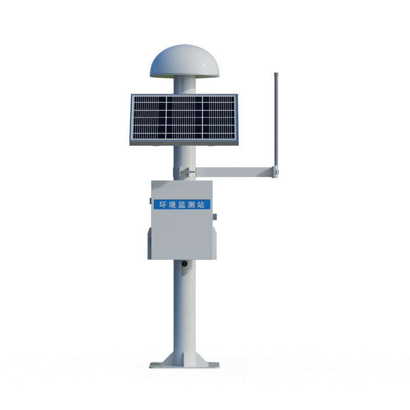
The Landslide Early Warning and Monitoring System employs GNSS and Differential RTK technologies to acquire surface displacement data with millimeter-level precision. By integrating data such as displacement and rainfall, the system automatically issues early warning alerts without the need for manual supervision; it is widely utilized in the prevention and mitigation of geological hazards, including landslides and debris flows.
The Landslide Early Warning and Monitoring System relies primarily on Global Navigation Satellite System (GNSS) technology to achieve high-precision acquisition of surface displacement data. The monitoring equipment receives multi-system, multi-frequency satellite signals—including those from BeiDou, GPS, GLONASS, and Galileo—and utilizes carrier-phase differential positioning algorithms to maintain measurement accuracy within the millimeter range. The FT-WY1 monitoring unit features a built-in high-precision Inertial Measurement Unit (IMU), enabling the simultaneous processing of satellite signals and attitude data to ensure stable measurements even in complex terrain environments. The GNSS displacement monitoring station operates fully automatically on a 24/7 basis, requiring no human intervention, and continuously provides displacement data even during rainy or snowy weather conditions.
The system comprises four distinct layers: data acquisition, transmission, processing, and early warning. The front-end acquisition subsystem consists of devices such as GNSS receivers, rain gauges, and crack meters, which are strategically installed at critical cross-sections of potential landslide bodies. The data communication subsystem transmits real-time displacement information to the back-end data analysis and processing platform via 4G networks or the BeiDou Short Message Service. In the case of the massive landslide at Leijiashan in Shimen, Hunan Province, the system successfully captured signals indicating slow displacement—amounting to tens of millimeters—prior to the actual occurrence of the disaster. A comprehensive monitoring solution typically involves establishing a hierarchical network comprising a reference station and multiple monitoring stations. Across a hazardous slope section spanning 2.8 kilometers, the deployment of monitoring nodes enables the continuous recording of cumulative deformation at the millimeter level.
The core logic underlying the landslide early warning system is predicated on the collaborative analysis of multi-source data. Since displacement data alone is often insufficient to accurately determine the precise timing of slope instability, the system simultaneously acquires auxiliary parameters such as rainfall intensity, groundwater levels, and inclination angles. The monitoring equipment establishes correlations between these variables through a "displacement-rainfall coupling model"; when multiple indicators simultaneously exceed their respective critical thresholds, the system automatically transmits an early warning notification to the management platform. Traditional solutions rely on multiple functionally independent devices to separately acquire data on displacement, fissures, rainfall, and groundwater levels; however, such devices are prone to issues—such as reduced stability and data transmission interruptions—when operating in harsh environments. To enhance adaptability to construction and field conditions, a new generation of monitoring equipment employs an integrated design approach for hardware integration, enabling the synchronous acquisition of multi-source data within a single unit, thereby significantly reducing the workload associated with device connection and calibration.
The timeliness of early warnings is inextricably linked to data communication capabilities. In a landslide monitoring system, the time lag between a sensor detecting a displacement change and the issuance of an early warning signal directly determines the available window for the effective evacuation of personnel. Smart geological hazard solutions powered by 5G networks enable data transmission with sub-second latency; by integrating with cloud-based analytical models to perform intelligent assessments, these systems establish the technical foundation necessary for the early identification of potential landslides. In a monitoring application implemented by the Chongqing Institute of Geology and Mineral Resources, a micro-vibration alarm device—utilizing a multi-point anomaly intensity factor algorithm—is capable of issuing tiered warnings seconds to tens of seconds prior to an impending landslide, thereby securing a precious evacuation window for personnel in threatened zones.
The system offers exceptional adaptability and flexibility regarding field deployment, eliminating the need to construct dedicated protective shelters for the front-end monitoring devices. Its column-mounted installation structure facilitates the rapid deployment of monitoring nodes across rugged, mountainous terrain; furthermore, the device enclosure features robust rain- and dust-proofing, and—when paired with solar power panels—enables long-term, maintenance-free operation in remote field environments. Data management is handled via a cloud-based platform, allowing users to access the backend interface at any time to view displacement trend curves for each monitoring node; even gradual deformations—characterized by average daily changes of less than 100 millimeters—are clearly visualized within these trend charts. Provinces such as Shaanxi and Gansu have already integrated these monitoring networks into their respective provincial-level platforms, enabling designated administrators to simultaneously access real-time data—including displacement rates and warning statuses—for all identified hazard sites via large-format dispatch screens and mobile devices, thereby providing essential foundational support for geological hazard prevention and mitigation efforts.
The core advantage of the Wireless Weather Station lies in its integrated composite meteorological sensor. This key component can accurately measure various meteorological parameters, effectively meeting application needs in different scenarios and providing reliable support for obtaining meteorolog...
As a professional monitoring tool specifically designed for the efficient operation of photovoltaic (PV) power plants, the Photovoltaic Weather Station features functional design, parameter selection, and data application that are deeply tailored to the actual needs of PV scenarios. It serves as a c...
As meteorological monitoring needs become increasingly diverse, traditional meteorological equipment faces challenges in installation convenience, data comprehensiveness, and environmental adaptability. Conventional miniature weather instruments often suffer from measurement errors caused by sensor...
Microwaves refer to electromagnetic waves with frequencies ranging from 300MHz to 300GHz and wavelengths from 1 millimeter to 1 meter. Due to their high frequency and short wavelength, they have strong directivity and penetrating power, enabling stable propagation under different meteorological cond...


 Skype
Skype
 whatsapp
 mail
mail