Tianyi Sensor IOT Technology Co., Ltd
Sales Manager:Ms. Emily Wang
Cel,Whatsapp,Wechat:+86 15898932201
Email:info@fengtutec.com
Add:No. 155 Optoelectronic Industry Accelerator, Gaoxin District, Weifang, Shandong, China


Sales Manager:Ms. Emily Wang
Cel,Whatsapp,Wechat:+86 15898932201
Email:info@fengtutec.com
Add:No. 155 Optoelectronic Industry Accelerator, Gaoxin District, Weifang, Shandong, China
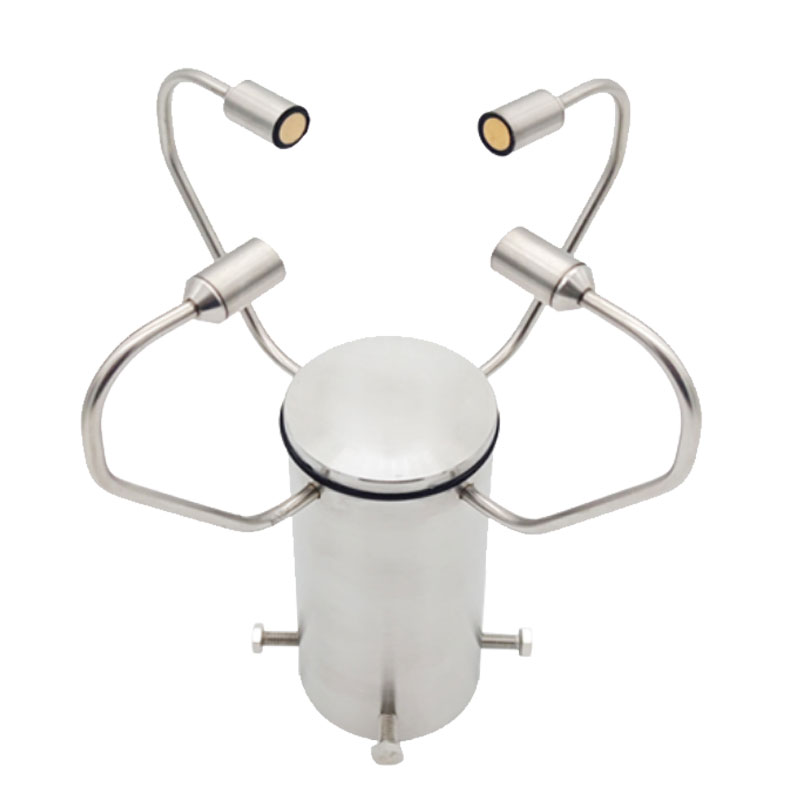
Model:FT-WQX2A2
Brand:tianyi
1.Introduction to 2D Ultrasonic Anemometer Products
2D Ultrasonic Anemometer is used for precise wind speed and direction measurement and is ideally suited for the meteorology and wind energy fields.The FT-WQX2A2 ultrasonic wind speed and direction sensor uses ultrasonic time difference method to measure wind speed and direction.High measurement accuracy, reliable performance, easy to carry, no moving parts, adopt an integral stainless steel shell, has IP66 protection grade, very stable structure, (optional) high-power self-heating module, can be extremely cold and frozen at high altitude It can also work normally in weather, and is a relatively advanced instrument for measuring wind speed and direction.
2.2D Ultrasonic Anemometer application field
It is widely used in urban environmental monitoring, civil market, wind power generation, meteorological monitoring, ship navigation and drilling operation platforms, high-speed railway and highway network, aviation airport environmental monitoring, subway, tunnel and mining and other fields.
3.2D Ultrasonic Anemometer product features
1.The integrated appearance design of stainless steel has a beautiful appearance.It uses independent research and development sensing technology to measure in real time.There is no starting wind speed limit or angle limit.At the same time, it obtains data on wind speed and wind direction.
2.Multiple ultrasonic probes send and receive ultrasonic signals in real time in the measurement space to ensure the parameters are efficient in real time.
3.High measurement accuracy, wide range, good stability performance, low power consumption, strong resistance to external interference, can work continuously, is not affected by weather changes, and does not require calibration.
4.Precision process, all-solid state design, stronger structure, high strength, weather resistance, corrosion resistance and water resistance, and long service life.
5.Professional integrated installation method, small size, easy to carry and install.
6.The internal heating device can be optionally installed according to the use environment (optional item), with the maximum heating power up to 120W
4.2D Ultrasonic Anemometer Technical Indicators
| Wind speed | Measurement range | 0~70 m/s |
| Start the wind speed | 0.1m/s | |
| Response time | 1s | |
| Resolution | 0.1m/s | |
| Accuracy | ±0.3m/s or ±3% (0-30m/s, the larger one) ±5% (30-70m/s) | |
| wind direction | Measurement range | 0-360° |
| Start the wind speed | 0.1m/s | |
| Accuracy | ±2° | |
| Resolution | 0.1° | |
| Heating options | Heating current | 0.6~1A |
| Power consumption | 15~25W | |
| Temperature control interval | -30~60℃ | |
| Basic parameters | Digital Signal | RS485 4-20mA |
| Baud rate | 9600, 19200, 38400, etc. | |
| Power supply voltage | 9~24VDC | |
| Average current | <35mA (12VDC) | |
| Operating temperature | -30~60°C | |
| Working humidity | 0~99%RH | |
| Protection level | IP66 |
Here's a little bit of knowledge: Bridges actually freeze more easily than road surfaces.Why is that?From the perspective of heat dissipation, the temperature difference between a bridge deck and an ordinary road surface is quite understandable. The road surface is directly built on the ground,...
Hydrological flow monitoring equipment plays a crucial role in water conservancy work, helping us grasp the dynamics of water resources and facilitating flood control, water dispatch, and other tasks. Below is a detailed introduction to common equipment.Water Level Monitoring StationThe battery-powe...
The growth of crops is closely linked to soil conditions. Harnessing the "advantages of the land" and carrying out crop cultivation in line with local conditions are core measures to increase crop yields. In agricultural production, links such as the selection of spring sowing timing, dete...
Although traditional mechanical wind speed and direction meters have, to some extent, met basic requirements, they have limitations in terms of accuracy, response speed, and reliability. With the advancement of technology, the 3D Ultrasonic Anemometer based on the time - difference method has been d...


 Get a Free Quote
 Skype
Skype
 whatsapp
 mail
mail