Tianyi Sensor IOT Technology Co., Ltd
Sales Manager:Ms. Emily Wang
Cel,Whatsapp,Wechat:+86 15898932201
Email:info@fengtutec.com
Add:No. 155 Optoelectronic Industry Accelerator, Gaoxin District, Weifang, Shandong, China


Sales Manager:Ms. Emily Wang
Cel,Whatsapp,Wechat:+86 15898932201
Email:info@fengtutec.com
Add:No. 155 Optoelectronic Industry Accelerator, Gaoxin District, Weifang, Shandong, China
time:2025-05-30 08:57:59 source:Weather Station viewed:390 time
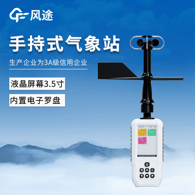
The Handheld Weather Station FT - SQ6+ takes "full - element monitoring + precise positioning + intelligent interconnection" as its core. It gives consideration to portability and professional performance. It not only meets the needs of mobile scenarios such as outdoor operations and emergency monitoring, but also can be connected to the cloud platform through accessories to integrate into the smart meteorological network. Its modular design (such as the 4G module and positioning mode) and flexible parameter settings (recording interval and wind direction mode) further enhance the equipment's scene adaptability and user - defined space. It is an efficient tool in the fields of meteorology, environmental protection, scientific research, and the outdoors.
The following are its functions and advantages:
I. Multi - functional integrated display, professional meteorological elements coverage
The 3.5 - inch liquid crystal screen intuitively presents more than 10 key meteorological data, including basic environmental parameters (wind speed, wind direction, temperature, humidity, atmospheric pressure, altitude) and professional analysis indicators (heat index, wet - bulb temperature, wave height), with GNSS three - mode positioning (Beidou + GPS + GLONASS) for real - time and accurate positioning.
It is suitable for scenarios such as outdoor operations, meteorological observations, and navigation/surfing. Users do not need to switch between multiple devices, and a single device can complete environmental monitoring and position tracking.
The wave height monitoring function is particularly suitable for professional needs such as marine scientific research and water sports safety assessment.
II. Electronic compass + intelligent wind direction monitoring, accurate and flexible wind direction data
It is equipped with a high - precision electronic compass, supporting 360 - degree omnidirectional wind direction monitoring, and providing dual - mode switching between automatic reading (real - time dynamic tracking) and manual reading (fixed - point locking).
The automatic mode is suitable for rapidly changing weather environments (such as typhoon warnings and field inspections), and can capture wind direction changes in real time.
The manual mode can lock a specific direction at a fixed observation point (such as a meteorological station and a construction site), which is convenient for long - term trend analysis.
The dual - mode design improves data collection efficiency and meets the needs of multiple scenarios such as scientific research observations and emergency responses.
III. Large - capacity storage + flexible recording interval, more efficient data management
It supports the storage of up to 40,000 meteorological data, and the recording interval can be freely set between 1 and 60 minutes to meet the needs of high - frequency real - time monitoring and long - term trend analysis.
High - frequency recording (such as 1 - minute interval) is suitable for continuous monitoring of severe weather (such as thunderstorms and severe convection).
Low - frequency recording (such as 60 - minute interval) is suitable for long - term environmental data archiving (such as climate change research and agricultural soil moisture monitoring).
Large - capacity storage reduces the risk of data overwriting and avoids the loss of key data.
IV. Type - C interface + high - speed data transmission, convenient docking with terminal devices
It is equipped with a Type - C communication interface, which can quickly export the data stored in the device to terminal devices such as computers and tablets. It is compatible with mainstream USB protocols, and the transmission is stable and efficient.
After field operations, the data can be reviewed immediately without relying on a wireless transmission environment, which is suitable for non - network scenarios (such as mountainous areas and polar scientific research).
It supports batch data import into analysis software (such as Excel and professional meteorological data platforms), improving data processing efficiency.
V. GNSS three - mode positioning (optional single Beidou), precise positioning and independent control
Three - mode positioning (Beidou + GPS + GLONASS): Multi - system integration improves positioning speed and accuracy, especially in complex terrains (such as canyons and urban high - rises), the anti - interference ability is stronger.
Single Beidou mode is optional: It supports domestic independent navigation and meets the needs of scenarios such as military industry and government affairs that have specific requirements for satellite systems.
In scenarios such as outdoor rescue and geological exploration, it can quickly lock the location information and shorten the response time.
It complies with the national information security strategy and is suitable for operations in sensitive areas.
VI. Long battery life + low power consumption design, all - weather continuous operation
It is equipped with a 3800mAh lithium battery. Combined with a low - power consumption chip and intelligent sleep technology, it can work continuously for 18 hours when fully charged, meeting the needs of all - weather operations.
A single charge can support all - day field monitoring (such as forest fire prevention patrols and marathon event security), reducing the trouble of frequent charging.
In the low - power consumption mode, the standby time is longer, which is suitable for unattended monitoring scenarios (such as automatic meteorological stations).
VII. Ergonomic design, both portability and professionalism
The structure is compact and lightweight, in line with the ergonomics of handheld devices. It is equipped with a portable lanyard or backpack interlayer and supports one - hand operation.
Field workers (such as meteorologists and outdoor anchors) can easily carry it, reducing equipment burden.
In emergency rescue scenarios, the equipment can be quickly deployed to improve the response speed.
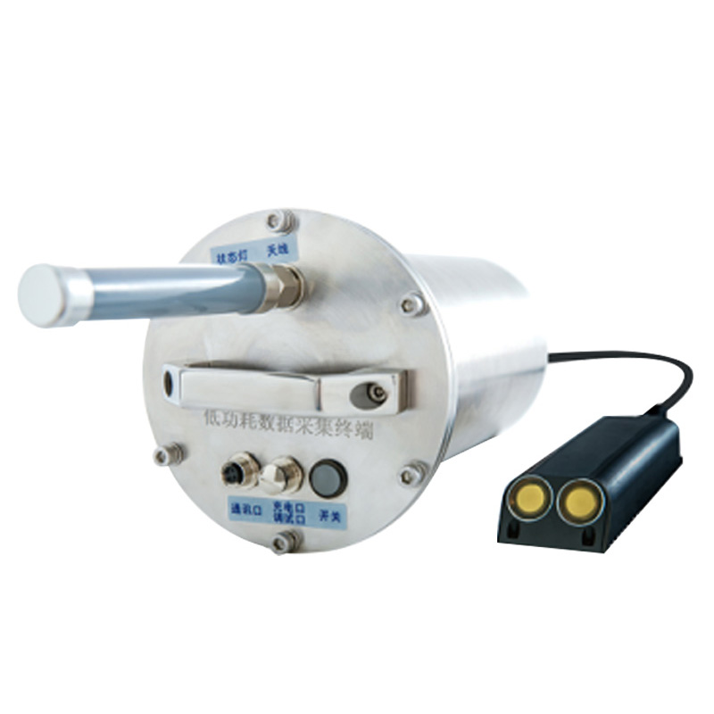
VIII. 4G module + cloud platform docking, building an intelligent monitoring network
The external DTU - 4G module supports hot swapping, and the IoT card can be replaced at any time to upload data to the cloud platform in real time, realizing remote monitoring and multi - device collaboration.
Real - time data synchronization is suitable for scenarios that require remote management, such as meteorological early warning systems and smart agricultural monitoring.
The modular design reduces the use cost, and users can flexibly replace the SIM card according to the traffic demand to avoid binding restrictions.
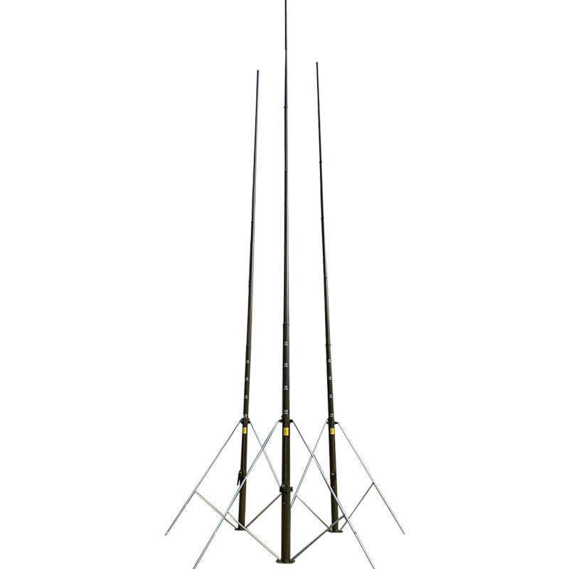
IX. Optional triangular bracket, expanding fixed monitoring scenarios
A professional triangular bracket can be optionally configured to convert the handheld device into a fixed monitoring station, supporting multi - angle adjustment and ground fixation.
Temporary meteorological observation points (such as disaster sites and large - scale event security) can be quickly built to improve stability.
In scientific research scenarios, it can be used with a tripod to extend exposure or fixed shooting, realizing the synchronization of data collection and image recording.
Traditional air quality monitoring stations (national and provincial control points) use extremely sophisticated and expensive equipment, resulting in very high construction and operational costs. Consequently, a city typically has only a handful of such stations. Due to the limited number of statio...
Displacement monitor device utilizes harmless laser technology to accurately detect minute displacements in building structures such as walls and beams after disasters like earthquakes and explosions. By identifying even the slightest unstable movement, this equipment provides timely warnings...
Piezoelectric Rain Gauge employs a PVDF piezoelectric film as its rain-sensing element, utilizing an embedded AI neural network to distinguish rain droplet signals and prevent false triggers caused by interference from grit, dust, vibration, and similar factors. The device features a completel...
Although traditional mechanical wind speed and direction meters have, to some extent, met basic requirements, they have limitations in terms of accuracy, response speed, and reliability. With the advancement of technology, the 3D Ultrasonic Anemometer based on the time - difference method has been d...


 Skype
Skype
 whatsapp
 mail
mail