Tianyi Sensor IOT Technology Co., Ltd
Sales Manager:Ms. Emily Wang
Cel,Whatsapp,Wechat:+86 15898932201
Email:info@fengtutec.com
Add:No. 155 Optoelectronic Industry Accelerator, Gaoxin District, Weifang, Shandong, China


Sales Manager:Ms. Emily Wang
Cel,Whatsapp,Wechat:+86 15898932201
Email:info@fengtutec.com
Add:No. 155 Optoelectronic Industry Accelerator, Gaoxin District, Weifang, Shandong, China
time:2025-11-26 11:22:10 source:Weather Station viewed:344 time
Road Weather Sensors is a professional optical instrument that estimates meteorological optical range by measuring the scattering intensity of light particles in the atmosphere. This device monitors the concentration of particles such as smoke, dust, haze, and fog, converting the atmospheric extinction coefficient into visibility data. It is widely used in meteorological monitoring, traffic management, and maritime applications.
Road Weather Sensors is an optical device specifically designed for measuring atmospheric visibility. By detecting the scattering effect of suspended particles in the atmosphere on light, the device accurately calculates the meteorological optical range, providing important data support for weather forecasting, traffic management, and environmental monitoring.
The core working principle of Road Weather Sensors is based on light scattering theory. The device emits a beam of infrared or visible light of a specific wavelength. When this beam of light passes through the atmospheric sampling area, it interacts with suspended particles in the air. These particles include various forms such as smoke, dust, haze, fog, rain, and snow. The particles cause the light to scatter, and the sensor measures the intensity of the scattered light at a specific angle using a precision photoelectric detector. The scattered light intensity has a definite physical relationship with the concentration and particle size distribution of particles in the air. Through an established algorithmic model, the measured scattered light intensity can be converted into an atmospheric extinction coefficient.
After obtaining the atmospheric extinction coefficient, the device further uses the Koschmieder formula to convert it into a meteorological visibility value. This conversion process considers the visual characteristics of the human eye and ambient lighting conditions, ensuring that the output visibility data conforms to the meteorological optical range standards stipulated by the World Meteorological Organization. The entire measurement process is fully automated, and the device can continuously sample and calculate, providing real-time visibility monitoring data.
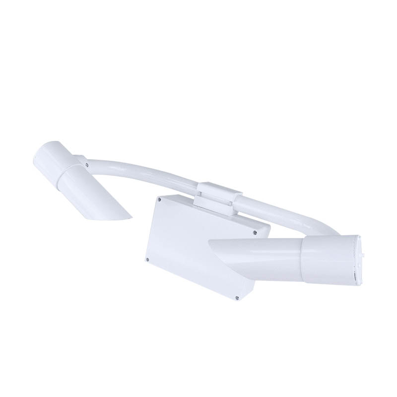
The hardware system of Road Weather Sensors mainly consists of a light source module, an optical sampling chamber, a signal detection unit, and a data processing module. The light source module generates a stable light beam, the optical sampling chamber provides a space for the interaction between light and atmospheric particles, the signal detection unit is responsible for collecting the scattered light signal, and the data processing module completes signal conversion and visibility calculation. The device casing adopts an anti-corrosion and dustproof design, capable of adapting to various harsh outdoor environmental conditions.
In the field of meteorological monitoring, Road Weather Sensors is mainly used for monitoring and early warning of low-visibility weather phenomena such as fog and haze. By continuously monitoring visibility trends, meteorological departments can accurately predict the formation and dissipation of fog and haze, and issue timely fog warnings. In traffic management, Road Weather Sensors is installed at important transportation hubs such as highways, airports, and ports, providing decision-making basis for traffic safety management. When visibility falls below the safety threshold, traffic management departments can take measures such as speed limits and road closures to ensure traffic safety.
The application of Road Weather Sensors in the maritime field is equally important. Visibility monitoring in ports and waterways directly relates to the safety of ship navigation, and accurate visibility data can help maritime departments formulate reasonable navigation plans. In environmental monitoring, visibility data reflects the degree of air pollution, providing a reference for environmental quality assessment. In addition, the equipment also plays an important role in urban planning, military support, and scientific research.
Modern Road Weather Sensors generally features automatic calibration, fault diagnosis, and remote data transmission functions. The equipment can automatically compensate for the influence of environmental factors such as temperature and humidity on the measurement, ensuring data accuracy. Through wired or wireless methods, monitoring data can be transmitted to the monitoring center in real time, enabling centralized management of the visibility network. With the continuous advancement of photoelectric technology and data processing algorithms, the measurement accuracy and reliability of Road Weather Sensors continue to improve, demonstrating its application value in more fields.
The Portable Visibility Monitor employs the forward scattering method to measure the total extinction coefficient of the air, offering a visibility range of up to 20 kilometers with a resolution of 1 meter. Compact and lightweight, the device is ready for immediate use upon power-up. It is wid...
The Weather Station Monitoring System is an important component of the overall environmental monitoring system. It is mainly used for real-time and continuous monitoring and data collection of various meteorological elements and related pollutants in the atmospheric environment, providing scientific...
Piezoelectric rain gauges use a PVDF piezoelectric film as the rain-sensing device and an embedded AI neural network to distinguish raindrop signals, avoiding false triggering caused by interference from sand, dust, vibration, etc. The device features a fully solid-state integrated design with...
What kinds of Wind Speed Sensors are there on the market and how should consumers choose?There are a wide variety of Wind Speed Sensors available in the market. However, according to the detection principles, they can be classified into mechanical sensors, ultrasonic sensors, thermal sensors, Pitot...


 Skype
Skype
 whatsapp
 mail
mail