Tianyi Sensor IOT Technology Co., Ltd
Sales Manager:Ms. Emily Wang
Cel,Whatsapp,Wechat:+86 15898932201
Email:info@fengtutec.com
Add:No. 155 Optoelectronic Industry Accelerator, Gaoxin District, Weifang, Shandong, China


Sales Manager:Ms. Emily Wang
Cel,Whatsapp,Wechat:+86 15898932201
Email:info@fengtutec.com
Add:No. 155 Optoelectronic Industry Accelerator, Gaoxin District, Weifang, Shandong, China
time:2026-05-29 10:51:42 source:Weather Station viewed:167 time
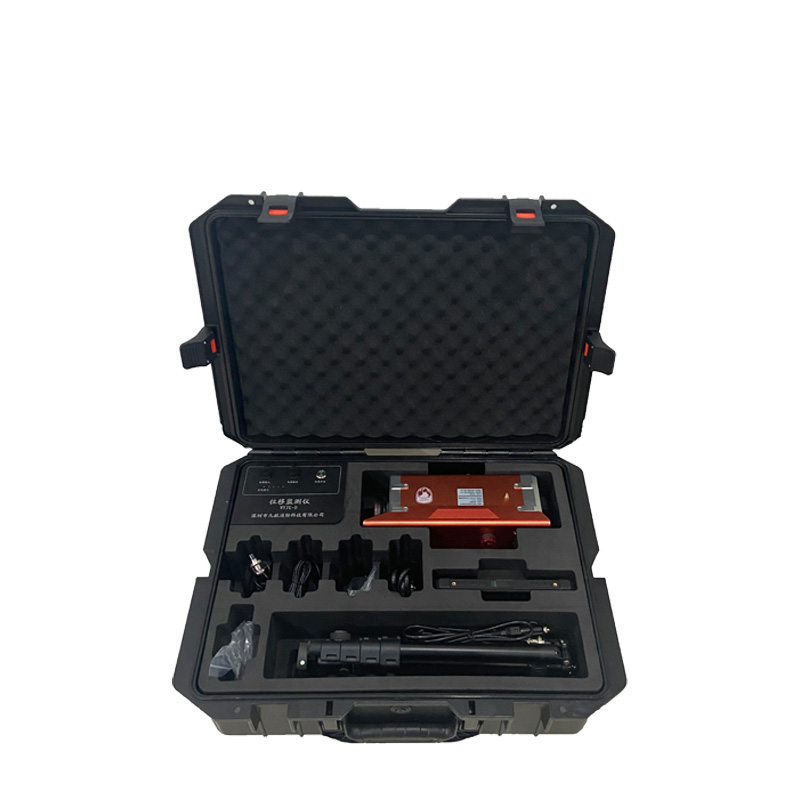
Geological disaster monitoring and early warning system consists of a control terminal host, displacement monitor, tilt monitor, telescopic sight, tripod, charger, and waterproof and shockproof packaging. The displacement monitor can be set with 9 fixed alarm values from 5 to 100mm via shortcut keys, or in 1mm increments, with an adjustment range of 1 to 9999mm continuously adjustable. The tilt monitor has a measurement accuracy ≤0.1°, supports 360° display on X, Y, and Z axes, and a resolution ≤0.01°. The alarm sound intensity is ≥120dB, supporting both fixed alarm values and arbitrarily set alarm values.
Geological disaster monitoring and early warning system is a type of high-precision equipment used for real-time monitoring of displacement and deformation of the ground surface, buildings, and engineering structures, mainly including GNSS Geological disaster monitoring and early warning system and machine vision displacement monitoring systems. This instrument consists of a control terminal host, displacement monitor, tilt monitor, telescopic sight, tripod, charger, and a waterproof and shockproof packaging case. The equipment is portable and can be quickly deployed in the work area, making it suitable for temporary emergency displacement monitoring tasks. Data is transmitted wirelessly, with a communication distance of ≥500 meters in open areas. It is equipped with an intelligent management cloud platform, where users can view the device's connection status, real-time detection information, device operating status, and battery information.
The alarm function is one of the core features of this device. The alarm threshold is adjustable as needed, supporting both fixed alarm values and arbitrarily set alarm values. The tilt monitor can be set with 7 fixed alarm thresholds (0.5°, 1.0°, 2.6°, 5.0°, 8.0°, 10.0°, 20.0°) via shortcut keys, or in 0.1° increments, with an adjustable range from 0.1 to 90° and continuously adjustable values. The displacement monitor can be set with 9 fixed alarm thresholds (5, 10, 15, 20, 30, 50, 70, 80, 100 mm) via shortcut keys, or in 1 mm increments, with an adjustable range of 1 to 9999 mm. Any scale value is continuously adjustable. The control terminal uses a full-color LCD screen (≥8 inches), supporting both button and touch operation. It has BeiDou positioning functionality and displays location information on the screen. The alarm sound intensity is ≥120dB, and the alarm sound can be turned on and off. An audible and visual alarm is automatically triggered when the monitored value deviates from the set value. The control terminal can be linked with other monitors for alarm monitoring.
Regarding accuracy, the tilt monitor has a measurement accuracy ≤0.1°, supporting 360° three-dimensional monitoring, simultaneously monitoring the X, Y, and Z axes, with a resolution ≤0.01°. The displacement monitor has a measurement accuracy ≤1 mm. All devices utilize wireless transmission with a communication distance of ≥500 meters. They feature voice alarms for proximity, distance, abnormal observations, and low battery. One-click search and one-click evacuation are supported, allowing each monitoring device to automatically alarm and its location to be reversed. Geological disaster monitoring and early warning system can be widely used in structural monitoring of subways, railways, bridges, tunnels, and dams. It supports battery power, external mains power, and onboard charging. The entire system can operate continuously for ≥12 hours, with an operating temperature range of -25℃ to 60℃ and a storage temperature range of -40℃ to 70℃.
The visibility meter uses forward scattering to measure the total extinction coefficient of the air and calculate the current visibility. It has a range of 10km, a resolution of 1m, and an error of ±2% for distances ≤2km, ±5% for distances between 2km and 10km, and ±10% for distances great...
An air quality monitoring station is an unmanned environmental monitoring device that integrates data collection, storage, transmission, and management. Its core advantage lies in its ability to conduct high-precision, real-time monitoring of various pollutants. The system can provide data on parame...
Against the backdrop of rapid industrialization, industrial parks—core hubs for industrial agglomeration—face prominent pollution discharge issues. These issues are characterized by complex compositions, diverse types, and high emission intensity. Among them, industrial clusters and parks involvin...
The water level and rainfall monitoring system utilizes K-band planar radar microwave technology to simultaneously monitor water levels and rainfall via non-contact methods. Characterized by low power consumption and high stability, the system is immune to various environmental factors and is suitab...


 Skype
Skype
 whatsapp
 mail
mail