Tianyi Sensor IOT Technology Co., Ltd
Sales Manager:Ms. Emily Wang
Cel,Whatsapp,Wechat:+86 15898932201
Email:info@fengtutec.com
Add:No. 155 Optoelectronic Industry Accelerator, Gaoxin District, Weifang, Shandong, China


Sales Manager:Ms. Emily Wang
Cel,Whatsapp,Wechat:+86 15898932201
Email:info@fengtutec.com
Add:No. 155 Optoelectronic Industry Accelerator, Gaoxin District, Weifang, Shandong, China
time:2026-03-02 11:19:43 source:Weather Station viewed:267 time
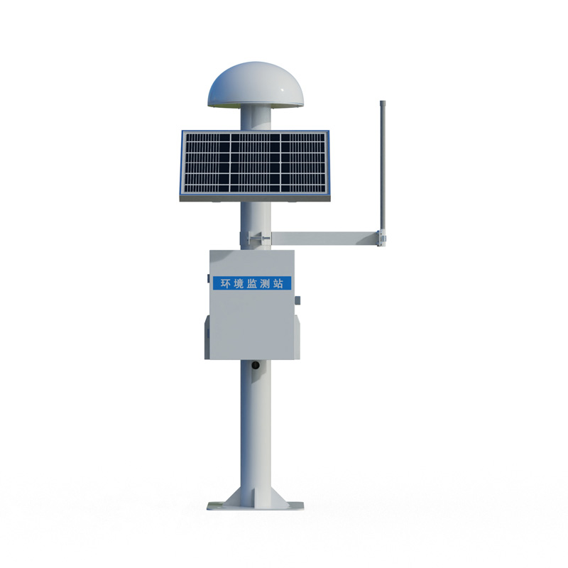
This landslide or collapse disaster monitoring equipment utilizes differential RTK technology, enabling millimeter-level displacement monitoring. Targeting geological hazards such as collapses, landslides, and debris flows, it provides long-term automated monitoring of unstable rock masses, collects real-time terrain change data, and issues timely early warnings to assist in emergency rescue and disaster relief.
This landslide or collapse disaster monitoring equipment is a geological hazard monitoring device developed based on differential RTK technology. Its core advantage lies in achieving millimeter-level displacement monitoring accuracy. It requires no on-site human supervision and can complete long-term automated monitoring of unstable rock masses and surrounding terrain, providing precise data support for geological hazard prevention and control. The differential RTK technology it employs eliminates measurement errors through the collaborative work of a base station and a rover station, ensuring the accuracy of displacement monitoring data and meeting the high standards required for geological hazard monitoring.
This equipment is specifically designed for common geological hazards such as landslides, collapses, and debris flows. Focusing on the dynamic changes of unstable rock masses, it can collect key data related to landslides and debris flows, such as topographic displacement and deformation, in real time. The entire process is automated, avoiding the lag and human error inherent in manual monitoring. The equipment boasts stable monitoring performance, adaptable to complex field environments such as mountains and steep slopes, and can operate stably for extended periods, comprehensively capturing subtle displacement changes in unstable rock masses to provide reliable data for disaster early warning.
As a professional geological hazard monitoring device, its core function is to promptly capture abnormal signals before a geological disaster occurs, issuing clear warnings to administrators, buying sufficient time for emergency response, assisting in emergency rescue work, and minimizing casualties and property losses. The equipment has a wide range of applications; in addition to monitoring landslides and collapses, it can also be used in various engineering fields such as dam safety monitoring, bridge health inspection, and landslide early warning, adapting to the monitoring needs of different scenarios.
In geological hazard prevention and control, this equipment can achieve 24/7, uninterrupted monitoring of unstable rock masses, transmitting monitoring data in real time, allowing administrators to grasp the geological conditions in real time, promptly identify potential hazards, and take preventive measures. Compared to traditional monitoring methods, this equipment boasts a high degree of automation and monitoring accuracy, significantly improving the efficiency and scientific rigor of geological disaster monitoring. The equipment is easy to operate and maintain, and can be quickly put into use after installation without complex debugging. It is a practical tool for long-term monitoring of geological disasters such as landslides and collapses, providing strong support for geological disaster prevention and control.
In today's society, with the acceleration of the processes of industrialization and urbanization, air quality issues have received increasing attention from people. There is a wide variety of pollutants in the air. Among them, the "four gases" (carbon monoxide, sulfur dioxide, nitrogen...
Meteorological stations are equipped with a variety of instruments to measure meteorological elements such as temperature, humidity, wind speed, wind direction, atmospheric pressure, and precipitation. Key instruments include platinum resistance temperature sensors, capacitive humidity sensors...
The Farmland Weather Station is a product of the integration of information technology and agricultural meteorological monitoring. By integrating multiple technical means, it achieves real-time and efficient processing of agricultural meteorological data, addressing the issues of delayed data collec...
Shandong Fengtu has launched a marine anemometer that integrates six meteorological parameters (temperature, humidity, wind speed, wind direction, air pressure, and rainfall) into one unit. It uses ultrasonic principles for wind measurement, with a range of 0-60 m/s, an accuracy of ±0.1 m/s,...


 Skype
Skype
 whatsapp
 mail
mail