Tianyi Sensor IOT Technology Co., Ltd
Sales Manager:Ms. Emily Wang
Cel,Whatsapp,Wechat:+86 15898932201
Email:info@fengtutec.com
Add:No. 155 Optoelectronic Industry Accelerator, Gaoxin District, Weifang, Shandong, China


Sales Manager:Ms. Emily Wang
Cel,Whatsapp,Wechat:+86 15898932201
Email:info@fengtutec.com
Add:No. 155 Optoelectronic Industry Accelerator, Gaoxin District, Weifang, Shandong, China
time:2026-09-11 10:43:42 source:Weather Station viewed:23 time
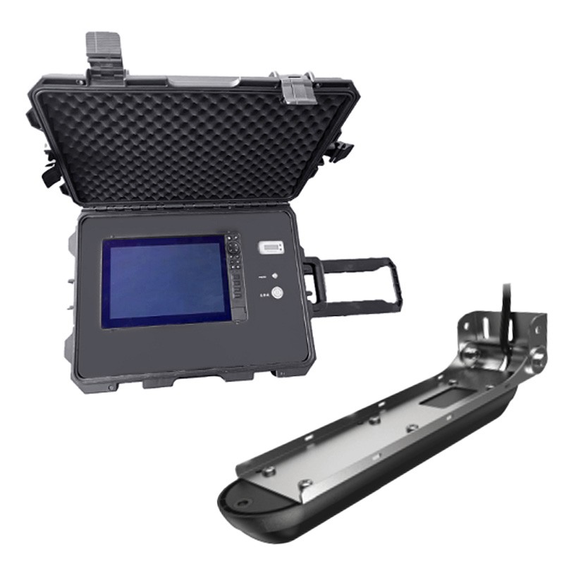
Utilizing high-definition imaging technology, the underwater side-scan sonar system performs comprehensive aquatic scanning and detection, visualizing underwater 3D structures and detecting living targets. With robust protection and high functional integration, it is suitable for various salvage and rescue scenarios, effectively enhancing the overall efficiency and precision of underwater operations.
Designed specifically for water-based salvage and emergency rescue, this professional detection device employs high-definition imaging technology to accurately scan riverbeds, map underwater structures, and detect underwater life. It provides clear visualizations of underwater terrain, obstacles, and target objects, offering reliable data support to operators and significantly improving the efficiency and safety of salvage and rescue missions.
The device features a 7-inch high-definition IPS display with high resolution and brightness, ensuring visibility in bright outdoor environments. It runs on a Chinese-language operating system that supports independent four-way split-screen control and customizable interface layouts, simultaneously displaying key data such as positioning, water temperature, operation time, and detection range. Five customizable shortcut keys streamline workflows to meet the demands of rapid operations. With an ultra-wide viewing angle, the device captures imagery across extensive areas without significant visual blind spots.
In terms of hardware durability and detection performance, the unit boasts an IP68 waterproof rating and withstands the pressure of operations at depths of up to 300 meters, making it suitable for complex environments ranging from shallow to deep water. It utilizes multi-frequency sonar capabilities; a dual-channel system ensures efficient detection with broad coverage for both side-scan and down-scan modes. With a maximum detection depth of 300 meters, it meets the requirements for deep-water salvage and large-scale area surveys. The device supports the recording and playback of sonar and scan data, facilitating post-operation analysis and mission reviews.
Integrating a range of practical functions, the sonar system is compatible with GPS, radar, and Automatic Identification Systems (AIS). It includes features such as global simplified nautical charts and an autopilot function, alongside dual alarm mechanisms for shallow water and GPS positioning, effectively mitigating safety risks during underwater operations. The unit is equipped with various data interfaces and high-capacity storage to meet data transmission and long-term storage requirements. Its power system supports both internal battery and external power sources, offering ample battery life and enabling uninterrupted operation via external power. Featuring a detachable mount and an adjustable handheld probe, the device can be rapidly installed on various types of work vessels; this flexible deployment makes it a core, specialized tool for aquatic salvage and rescue operations.
Underwater search and rescue robot is a high-performance underwater detection device integrating sonar scanning and high-definition video imaging. It uses sonar for large-area scanning and positioning, combined with high-definition video for detailed observation, providing scanned and 3D views of riverbeds and water bodies. It accurately identifies the outlines and locations of underwater targets and is widely used in underwater surveying and exploration....
As a key device in modern meteorological monitoring, one of the primary advantages of the wireless Small Automatic Weather Station is its adoption of wireless data transmission technology.1. Freedom from Wired Infrastructure LimitationsTraditional wired weather stations are constrained by cabling, b...
Meteorology and soil moisture are two fundamental elements in agriculture. Meteorology determines the "timing" of agriculture, while soil moisture reflects the "favorable geographical conditions". Together, they form the environmental framework for crop growth.The dynamic changes...
Anemometer sensors are categorized into two main types based on their operating principles: mechanical and ultrasonic. Mechanical sensors feature structures such as wind cups or propellers, while ultrasonic sensors rely on the time-of-flight method for measurement. Different models are suited...



 Skype
 whatsapp
 mail