Tianyi Sensor IOT Technology Co., Ltd
Sales Manager:Ms. Emily Wang
Cel,Whatsapp,Wechat:+86 15898932201
Email:info@fengtutec.com
Add:No. 155 Optoelectronic Industry Accelerator, Gaoxin District, Weifang, Shandong, China


Sales Manager:Ms. Emily Wang
Cel,Whatsapp,Wechat:+86 15898932201
Email:info@fengtutec.com
Add:No. 155 Optoelectronic Industry Accelerator, Gaoxin District, Weifang, Shandong, China
time:2025-12-29 10:44:12 source:Weather Station viewed:364 time
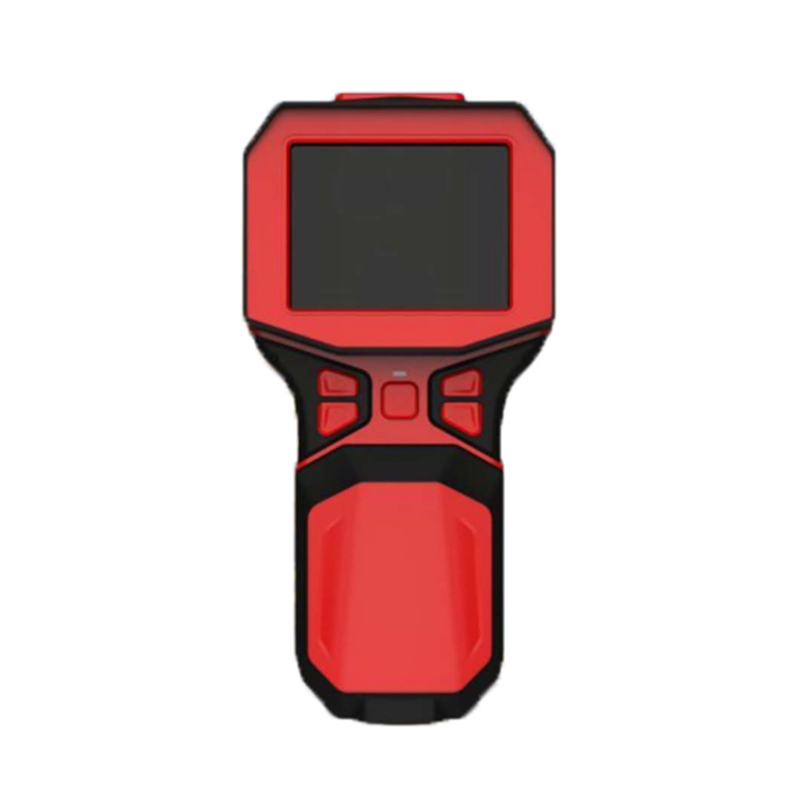
Infrared Thermal Imaging Camera is an electronic instrument based on the principle of infrared radiation detection, It receives infrared radiation energy emitted from the surface of an object in a non-contact manner and converts it into a visible thermal image to reflect the temperature distribution of the target. This device supports multiple display and analysis modes.
Infrared Thermal Imaging Camera is a device that utilizes an infrared detector and an optical imaging lens to receive the infrared radiation energy distribution pattern from the surface of the measured target. This energy distribution pattern is converted into an electrical signal through photoelectric conversion and signal processing, ultimately forming a visible thermal image on the display terminal that corresponds to the thermal distribution of the object's surface. The core principle is that any object with a temperature above absolute zero continuously radiates infrared energy, and there is a definite relationship between the radiation intensity and temperature. The instrument detects this invisible infrared radiation and converts it into temperature values and a visual image based on Planck's radiation law.
A complete Infrared Thermal Imaging Camera typically consists of an optical lens, an infrared detector, a signal processing circuit, a display unit, and analysis software. The optical lens collects and focuses the infrared radiation emitted by the target. The infrared detector is the core sensor, converting the focused radiation energy into an electrical signal. The signal processing circuit amplifies, corrects, and digitizes the raw electrical signal to eliminate environmental interference and compensate for the instrument's own effects. Finally, the processed data generates a thermal image on the display screen, using different colors or grayscale levels to represent the temperature distribution.
This device usually supports multiple display and analysis modes to suit different application scenarios. Common modes include white-hot mode (high temperatures displayed as white, low temperatures as black) and black-hot mode (the opposite). In addition, there are fire modes for firefighting (highlighting high-temperature areas), search and rescue modes for night observation, and visible light and thermal image fusion modes or picture-in-picture modes for easier comparison. These modes enhance the device's applicability and ease of interpretation in different professional fields.
The applications of Infrared Thermal Imaging Camera are very wide. In the industrial field, it is a key tool for predictive maintenance, used to detect overheating faults in electrical equipment (such as transformers and switchgear), troubleshoot pipe blockages or leaks, assess building exterior wall insulation defects, and monitor the temperature uniformity of production processes. In the field of fire protection and public safety, firefighters use it to penetrate dense smoke to find fire sources and trapped people; security personnel use it for night patrols, searches, and monitoring. In the fields of scientific research and medicine, it assists in non-contact temperature measurement tasks such as material research, electronic circuit analysis, and surface temperature screening.
The device's greatest advantage lies in its non-contact, large-area, and rapid imaging capabilities. It does not require contact with the object being measured, thus avoiding interference with the target's temperature field, and can instantly acquire temperature distribution information over a large area, enabling highly efficient inspection and diagnosis. By identifying abnormal temperature points or distribution patterns, it can provide early warnings before equipment failure or at the early stages of potential problems.
When using Infrared Thermal Imaging Camera, operators need to pay attention to environmental conditions (such as ambient temperature, humidity, and air cleanliness) and the emissivity of the target surface, as these factors can affect the accuracy of temperature measurement. Routine maintenance mainly includes keeping the lens clean and performing regular calibration. With technological advancements, modern infrared thermal imagers are developing towards higher resolution, higher temperature measurement accuracy, greater intelligence (such as integrated AI recognition algorithms), and more convenient forms (such as integration with smartphones), making their applications more widespread and sophisticated across various industries.
The Portable Weather Station is a professional device specifically designed for environmental monitoring. It is not only easy to install and operate with straightforward instructions but also delivers highly accurate measurement data. As a reliable observation system, it can simultaneously monitor m...
I. Product IntroductionOur company is a professional manufacturer of meteorological sensors. We have been focusing on the research and development, as well as the production of various meteorological sensors, and also provide meteorological environment solutions. The company has a complete productio...
Wind speed and direction are important parameters in meteorological observation and environmental monitoring, and they play a significant role in many fields such as agricultural production, aerospace, and energy development. Accurate wind speed and direction data can provide strong support for disa...
In the process of coal mine production, wind measurement work is of great importance. The space underground in coal mines is relatively enclosed, and there are flammable and explosive substances such as gas and coal dust. Reasonable ventilation can effectively dilute and discharge gas, reduce the ga...


 Skype
Skype
 whatsapp
 mail
mail