Tianyi Sensor IOT Technology Co., Ltd
Sales Manager:Ms. Emily Wang
Cel,Whatsapp,Wechat:+86 15898932201
Email:info@fengtutec.com
Add:No. 155 Optoelectronic Industry Accelerator, Gaoxin District, Weifang, Shandong, China


Sales Manager:Ms. Emily Wang
Cel,Whatsapp,Wechat:+86 15898932201
Email:info@fengtutec.com
Add:No. 155 Optoelectronic Industry Accelerator, Gaoxin District, Weifang, Shandong, China
Model:FT-DZ1
Brand:tianyi
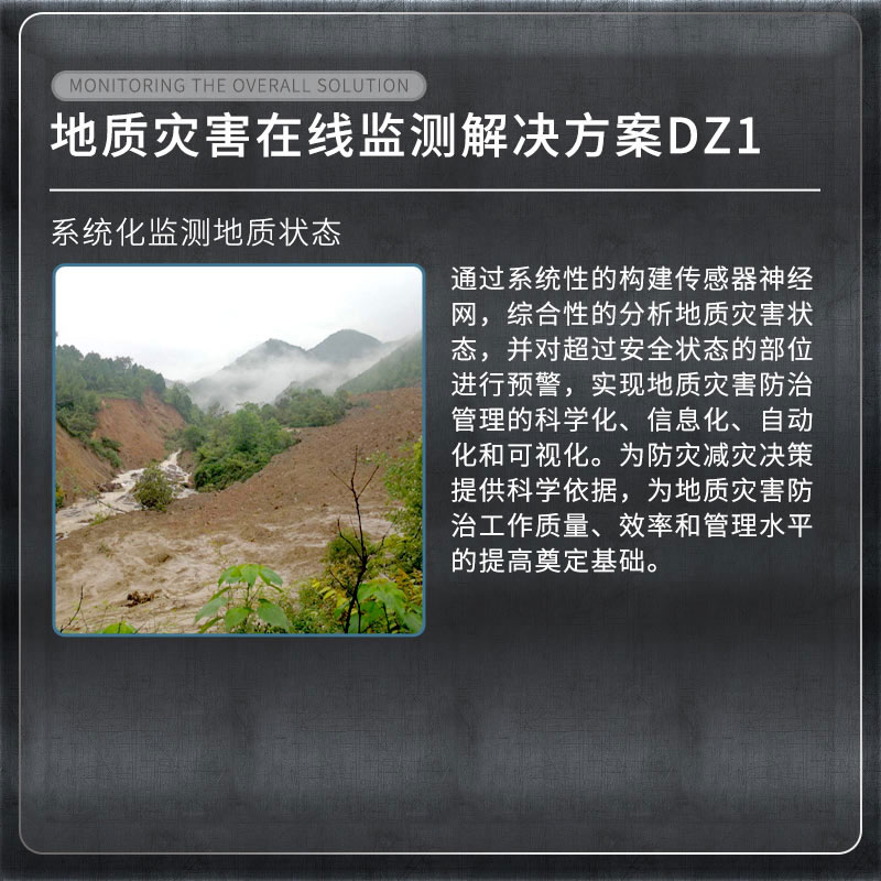
1.Geological disaster monitoring background
Geological disaster monitoring mainly includes displacement monitoring, crack monitoring, deep groundwater level monitoring, soil moisture content, rainfall, etc.Geological disasters come from catastrophic damage to the geological environment by natural and man-made geological effects, mainly including collapses, landslides, mudslides, ground collapses and ground cracks.my country has complex and diverse geological disasters and frequent disasters, making it one of the most serious geological disasters in the world.In recent years, research on landslide and mudslide disasters has been the focus of industry research.In order to enhance the awareness of disaster prevention and reduction in the whole society, reduce casualties, maintain social stability and normal production and living order, improve people's quality of life, promote the economic construction in areas with serious geological disasters and the comprehensive development of various social undertakings, and enable the people to live and work in peace and contentment, it has become an urgent task to do a good job in geological disaster warning and forecasting.
2.Overview of Geological disaster monitoring system
As a pioneer in industry monitoring, our company is the first to combine structural health monitoring with Internet of Things, cloud computing and other technologies.By systematically building sensor neural networks, comprehensively analyzing geological disaster status, and early warning of parts that exceed the safety status, so as to achieve scientific, informatized, automated and visualization of geological disaster prevention and control management.Provide scientific basis for disaster prevention and mitigation decisions, and lay the foundation for improving the quality, efficiency and management level of geological disaster prevention and control work.
3.List of Geological Disaster Monitoring Monitoring Projects
| Monitoring items | Device name |
| Surface displacement monitoring | Integrated GNSS monitoring system |
| Crack monitoring | Integrated surface displacement monitoring system |
| Deep displacement monitoring | Integrated deep displacement monitoring system |
| Groundwater level monitoring | Integrated pore water pressure monitoring system |
| Soil moisture content | Integrated soil temperature and humidity monitoring system |
| Rainfall | Integrated rainfall monitoring system |
| Video surveillance | Integrated video surveillance system |
| Mud level | Sludge level monitor |
4.Geological disaster monitoring basis
"Technical Specifications for Geological Disaster Monitoring DB11∕T 1677-2019"
"Geological Disaster Control Engineering Construction Safety Monitoring Specification T∕CAGHP 044-2018"
"Specifications on Monitoring of Collapse, Landslide and Mudslides"
"Technical Specifications for Groundwater Environmental Monitoring HJ/T164-2004"
"Geological Disaster Prevention and Control Engineering Survey Standard DB50∕143-2003"
5.Geological disaster monitoring implementation function
1.Through the automated monitoring platform, help management units realize geological information security monitoring and process management, and no longer be affected by the weather.Once an early warning occurs at any location on the scene, you can grasp the on-site situation through video monitoring, and take different alarm methods according to the warning level, and take emergency plan measures in a timely manner in combination with the relevant responsible units to evacuate the crowds, transfer in a timely manner to reduce accidents and disasters.
2.Achieve multi-level early warning and alarm mechanism from provinces, cities, counties and townships, provide emergency plans after early warning, and realize integrated disaster monitoring, early warning and response.Real-time long-term automated monitoring to prevent major landslides and mudslides and other geological disasters, reduce economic losses, and maintain social stability.
Tianyi specializes in the research, development and production of meteorological monitoring equipment, with profound technical strength and rich experience in the field of Automatic Farmland Weather Station. The weather stations produced by the company feature high-precision sensors and are made of...
Geological disaster monitoring and early warning system consists of a control terminal host, displacement monitor, tilt monitor, telescopic sight, tripod, charger, and waterproof and shockproof packaging. The displacement monitor can be set with 9 fixed alarm values from 5 to 100mm via shortcu...
The traditional meteorological monitoring stations have limited distribution, making it difficult to comprehensively and real-timely grasp the complex and changeable meteorological conditions. However, combining drones with meteorological instruments has unexpectedly become a solution to make up for...
People have been measuring the wind for a long time, and the tools for wind measurement have been constantly upgraded. In the 15th century, Leonardo da Vinci designed a vane anemometer, marking the beginning of the era of scientific wind measurement. In 1846, Thomas Romney Robinson, a British naval...


 Get a Free Quote
 Skype
Skype
 whatsapp
 mail
mail