Tianyi Sensor IOT Technology Co., Ltd
Sales Manager:Ms. Emily Wang
Cel,Whatsapp,Wechat:+86 15898932201
Email:info@fengtutec.com
Add:No. 155 Optoelectronic Industry Accelerator, Gaoxin District, Weifang, Shandong, China


Sales Manager:Ms. Emily Wang
Cel,Whatsapp,Wechat:+86 15898932201
Email:info@fengtutec.com
Add:No. 155 Optoelectronic Industry Accelerator, Gaoxin District, Weifang, Shandong, China
Model:FT-WS+
Brand:tianyi
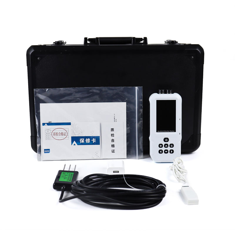
1、4G Soil Temperature and Moisture Meter Product Introduction
4G Soil Temperature and Moisture Meter is a highly integrated, multi-functional environmental monitoring device.Featuring an all-in-one design, it can quickly and accurately measure soil moisture content and temperature.This instrument is suitable for real-time monitoring of soil parameters at multiple locations and depths, and also supports long-term continuous monitoring, providing users with detailed soil data analysis.
It is widely used in various industries, including agriculture, forestry, geological exploration, plant cultivation, water conservancy, and environmental protection.It provides scientific basis and technical support for soil moisture monitoring, drought-resistant irrigation, and precision agriculture, helping users better understand and optimize soil conditions and promote sustainable development practices.
2、4G Soil Temperature and Moisture Meter Features:
1.Compact and aesthetically pleasing design: The compact design makes it easy to carry for field work and suitable for prolonged outdoor use.
Simple and easy-to-use interface: Users can start using the device without complex training.After connecting the sensor to the main unit, data can be manually stored or automatically recorded at user-defined sampling intervals, ensuring an efficient workflow.
2.Large color LCD screen: Real-time tracking and recording of values, groups, and low voltage status of various measured environmental factors (such as water content and temperature), providing clear and easily understandable information.
3.Built-in large-capacity memory: Supports data storage of up to 10 million entries and features power-off data protection, ensuring data security and integrity.
4.Automatic sensor recognition: After inserting sensors with different parameters, the main unit can automatically recognize them, ensuring consistency between sensors and maintaining measurement accuracy.
Flexible sensor combination: Users can combine sensors according to their needs.Sensor interfaces for different parameters are interchangeable, adapting to diverse measurement requirements.
5.Multi-channel automatic detection expansion: Supports simultaneous connection and synchronous detection of multiple sensors, improving work efficiency, especially suitable for situations requiring measurements at multiple locations or depths.
6.Convenient data export: Recorded data can be exported to a computer via the USB interface at any time, supporting Excel format output and generating data curves for further data analysis and processing.
7.Wireless upload to cloud platform: Equipped with standard 4G networking capabilities, it can wirelessly upload historical data stored on the device to the smart cloud agriculture platform, enabling remote data management and long-term trend analysis, greatly enhancing the user experience.
Data management platform: Users can access the cloud platform via the internet to view and manage data anytime, anywhere, improving data utilization efficiency.
3、4G Soil Temperature and Moisture Meter Host parameters
| Parameter name | Parameter range |
| Screen size | 3.5 inch high-definition color LCD screen |
| Screen resolution | 320*480 |
| Dual power supply | Built-in lithium battery/Type-C charging |
| Battery | 3800mAh built-in large capacity lithium battery |
| Electrode plug | 2x485 ports |
| Electrode cable harness | Single head 485/one to many 485 cable harness. Default 5 meters, can be customized according to user needs. |
| Storage capacity | 8G/Single parameter 280 million |
| Storage time | 5/10/15/30/60/300 seconds adjustable |
| Historical data | Support for viewing historical data |
| Data Export | USB connection to the computer to generate a virtual hard disk, which can view historical data |
| Data export format | Excel spreadsheets, one file per day, for easy data filtering and viewing. |
| Instrument size | 167*80*30mm |
| Instrument weight | 263g |
| Ambient temperature | 0-40℃ |
| Environmental humidity | Relative humidity ≤ 85% RH (no condensation) |
| Attachment box | Black aluminum alloy outer box |
| Waterproof grade | Host IP65/Electrode IP68 |
| Switch between Chinese and English | Support |
| Operation mode | Pure key, setting/OK same key, wet hands do not affect operation |
| Sensor communication method | RS485MODBUSRTU |
| External 4G module | DTU-4G (optional) |
| GNSS positioning | Optional (optional) |
4、4G Soil Temperature and Moisture Meter Sensor parameters
| Element; | Measurement range | Precision | Resolution |
| Soil temperature | -30~70℃ | ±0.3(-10~50℃) | 0.01℃ |
| Soil moisture content | 0~100% | ±3% (silt loam) High organic matter soil (soil organic carbon content >12%) High clay content soil (clay content >45%) may require calibration for specific soil types due to their dielectric relaxation properties; | 0.01% |
The traditional meteorological monitoring stations have limited distribution, making it difficult to comprehensively and real-timely grasp the complex and changeable meteorological conditions. However, combining drones with meteorological instruments has unexpectedly become a solution to make up for...
Weather conditions have always been a key factor affecting crop growth and harvest. Alas! Frequent meteorological disasters have brought great crises to agriculture!Drought, a common meteorological disaster, results from prolonged precipitation scarcity, leading to soil water shortage and dry air. C...
This system employs a twelve-element integrated sensor to simultaneously monitor parameters such as wind speed, wind direction, temperature, humidity, air pressure, optical rainfall, and PM2.5, PM10, CO, NO2, SO2, and O3. The equipment requires no debugging, can be quickly deployed, and is sui...
In the cold winter, transmission lines often face severe challenges of icing. When conditions such as low temperature, high humidity, and specific wind speed occur simultaneously, the phenomenon of icing on transmission lines is likely to form. Line icing not only increases the mechanical load on co...


 Get a Free Quote

 Skype
Skype
 whatsapp
 mail
mail