Tianyi Sensor IOT Technology Co., Ltd
Sales Manager:Ms. Emily Wang
Cel,Whatsapp,Wechat:+86 15898932201
Email:info@fengtutec.com
Add:No. 155 Optoelectronic Industry Accelerator, Gaoxin District, Weifang, Shandong, China


Sales Manager:Ms. Emily Wang
Cel,Whatsapp,Wechat:+86 15898932201
Email:info@fengtutec.com
Add:No. 155 Optoelectronic Industry Accelerator, Gaoxin District, Weifang, Shandong, China
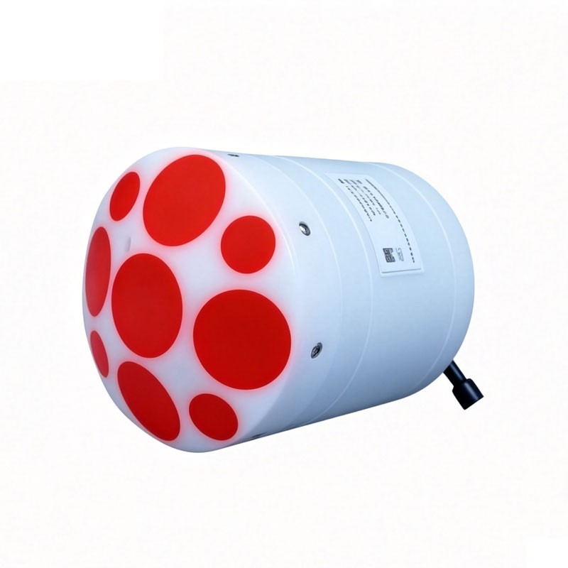
Model:ADCP-1+
Brand:tianyi
River ADCP Product introduction and technical parameters:
River ADCP is used to measure the flow velocity and flow rate of water bodies such as rivers, streams, and estuaries, and uses sound waves to measure the flow velocity at different depths.
| Composition | Technical Specifications | Parameters |
| Flow rate measurement | Operation Mode | Direct reading |
| Profile scope | 0.06-40m | |
| Flow measurement accuracy (typical) | ±0.25%±2mm/s | |
| Flow rate resolution | 1mm/s | |
| Speed test range | ±20.0m/s | |
| Flow measurement range | 0-360° | |
| Flow measurement accuracy | ±2° | |
| Number of units | 1-255 | |
| Unit layer thickness | 0.02-4m | |
| Transducer | Beam count | 9 transducers; dual 4-beam 3.0MHz/1.0MHz Janus; 1 0.5MHz vertical beam echo sounder |
| Beam angle | 25° | |
| Deep measurement | Height measurement resolution | 0.001m |
| Height measurement accuracy | 1% (full water column speed of sound corrected to 0.02%) | |
| Height measurement range | 0.2-80m | |
| Flow measurement | Bottom tracking range | 0.3-40m |
| GNSS/GPS Range | 0.3-80m, extrapolation for over 40m | |
| Internal storage | 64GB | |
| Water depth terrain measurement | Scope | 40m (slant beam) - 80m (vertical beam) |
| Velocity profile measurement range | ±10.0m/s | |
| Communication | Communication Interface | RS-232 or RS-422 |
| GNSS/GPS Communication | RS-232 Serial Input | |
| Maximum data refresh rate (output rate) | 2Hz | |
| Internal sampling rate | Maximum 70Hz | |
| Sensor | Temperature sensor | Accuracy: ±0.1℃; Resolution: 0.01℃ |
| Pressure sensor | Range: Determined by the depth rating; Accuracy: ±0.25%; Resolution: 1mm | |
| Attitude compass sensor | Range: Heading 0-360°; Accuracy (RMS): Roll ±1° | Pitch ±1° | Heading 0.8°; Resolution: 0.01° | |
| Power supply | Power supply interface | 10-26V |
| Structure | Casing material | POM |
| Environment | Operating temperature | -5℃-45℃ |
| Storage temperature | -40℃-70℃ | |
| Physical properties | Pressure depth | 50m |
| Weight (in air) | ≤1.5kg | |
| Size | Φ128mm×168mm | |
| Optional | Available options | - |
COD Analyzer complies with the national standard HJ828-2017 and employs the potassium dichromate oxidation spectrophotometric method. It enhances detection accuracy through dilution injection and chloride ion masking technology. The equipment boasts strong anti-interference capabilities, conve...
Atmospheric Visibility Sensor Utilizing the forward-scattering method to measure the total atmospheric extinction coefficient, this device accurately calculates meteorological optical range and visibility values. It features excellent protective capabilities, ultra-low power consumption, and stable...
The water and rainwater detection equipment, namely the Water Level Monitoring System, can efficiently and accurately obtain data such as water level, flow rate, and rainfall.The Water Level Monitoring System is a fully automatic hydrological online monitoring system based on microwave technology. I...
The price of a 3D anemometer varies depending on the model and configuration. The FT-SWF1 costs 16,000 yuan, while the FT-SWF2 costs 18,000 yuan. When purchasing, factors such as product performance, installation accessories, and after-sales support must be considered. The p...


 Get a Free Quote
 Skype
Skype
 whatsapp
 mail
mail