Tianyi Sensor IOT Technology Co., Ltd
Sales Manager:Ms. Emily Wang
Cel,Whatsapp,Wechat:+86 15898932201
Email:info@fengtutec.com
Add:No. 155 Optoelectronic Industry Accelerator, Gaoxin District, Weifang, Shandong, China


Sales Manager:Ms. Emily Wang
Cel,Whatsapp,Wechat:+86 15898932201
Email:info@fengtutec.com
Add:No. 155 Optoelectronic Industry Accelerator, Gaoxin District, Weifang, Shandong, China
Model:FT-SQ12
Brand:tianyi
1.Introduction to Pocket Weather Meter Products
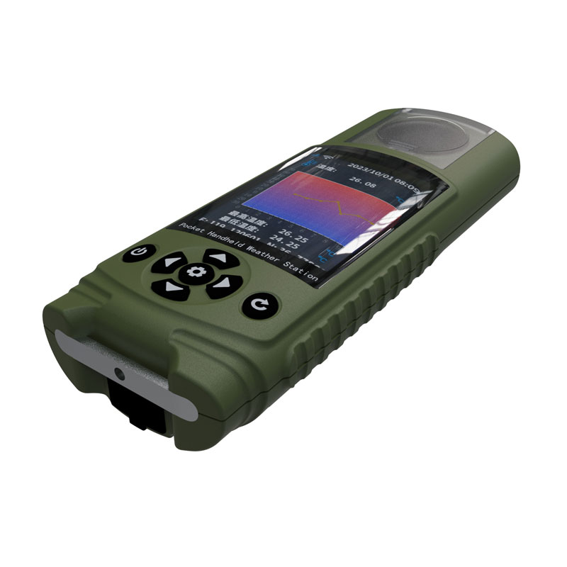
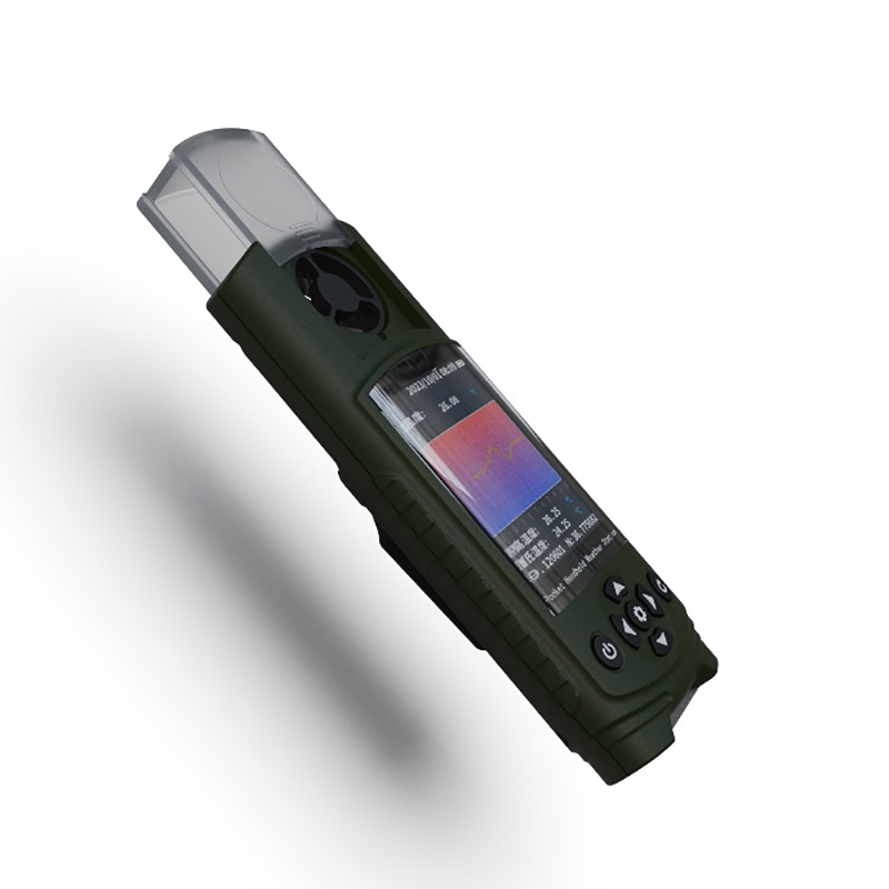
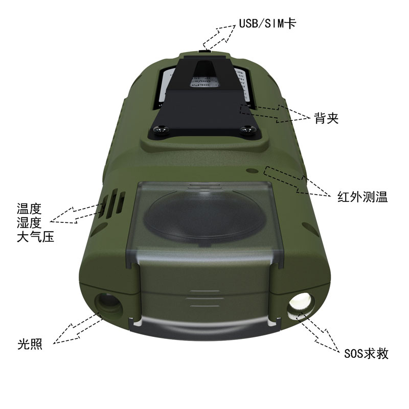
Pocket Weather Meter can measure ambient environmental factors such as temperature, humidity, pressure, wind speed, wind direction, UV, light, and total radiation.This product provides real-time measurement of parameters such as temperature, humidity, atmospheric pressure, wind speed, wind direction, light, total radiation, ultraviolet radiation, runway temperature, etc.
It also has outdoor SOS help, electronic compass, runway temperature, weather forecast for the next 3 hours, human comfort, radio silence, GNSS positioning and other functions.
At the same time, wireless transmission (4GCat1), WiFi upload cloud platform or LAN server is realized, and USB can read internal storage data.
This instrument can be widely used in meteorological, environmental protection, airports, agriculture and forestry, hydrology, military, warehousing, scientific research and other fields.
2.Pocket Weather Meter Technical Parameters
| Meteorological parameters | Measurement elements | Measurement range | Accuracy | Resolution | unit |
| temperature | -45-130 | ±0.2 | 0.01 | ℃ | |
| humidity | 0-100 | ±2.0 | 0.01 | % | |
| Atmospheric pressure | 30-110 | ±0.01 | 0.01 | KPa | |
| Wind speed | 0-40 | ±1 | 0.01 | m/s | |
| wind direction | 0-359 | ±1 | 1 | ° | |
| illumination | 0-157286 | <±3% | 1 | Lux | |
| Total radiation | 0-1242 | <±3% | 1 | W/㎡ | |
| Ultraviolet rays | 0-262144 | <±3% | 1 | mW/㎡ | |
| Runway temperature | -40- 85 | ±0.5 | 0.01 | ℃ | |
| Electronic compass | 0-359 | 1 | 1 | Spend | |
| GNSS Positioning | Positioning accuracy 2m | ||||
| SOS seeking rescue | International Morse Code Rescue Signal | ||||
| Battery | 3800mAh | ||||
| Communication | 4G Cat1, Wifi, USB | ||||
| Radio silence | Disable device 4G CAT1 communication and enter flight mode | ||||
| Human comfort | Calculate the current human comfort level based on the SET model | ||||
| Weather forecast for the next 3 hours | Deduce the three-hour weather conditions based on temperature, humidity, atmospheric pressure, light, ultraviolet rays, wind speed and other information | ||||
| storage | 6MB storage (90,000 pieces of data) | ||||
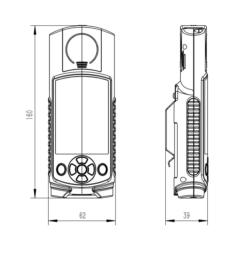
| Host size | 160*62*40 mm | ||||
| Working environment | -20℃~80℃; 5%RH~95%RH | ||||
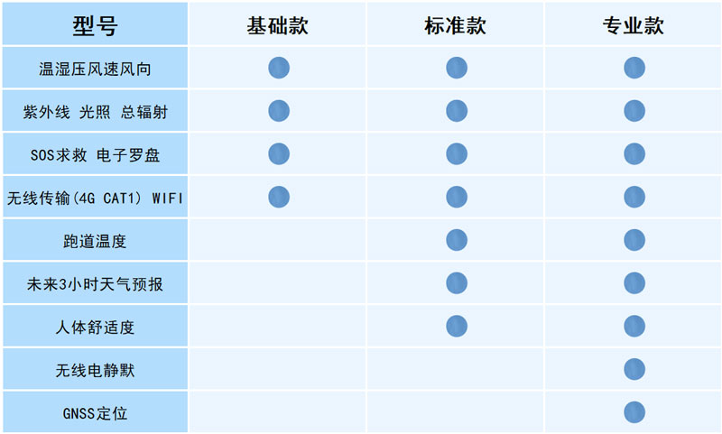
3.Pocket Weather Meter configuration instructions
4.Pocket Weather Meter product appearance diagram
5.Pocket Weather Meter Product Size Diagram
6.Pocket Weather Meter Shipping List
| name | quantity |
| Host | 1 |
| Charging head | 1 |
| Data line | 1 |
| manual | 1 |
| Certificate of conformity | 1 |
| Warranty card | 1 |
| Packaging box | 1 |
Stainless Steel Tipping Bucket Rain Gauge is a hydrometeorological instrument designed to measure natural rainfall. It features an error margin of ≤±2%, a resolution of 0.2 mm, and a rainfall intensity range of 0 to 4 mm/min. Supporting Modbus 485 output, the device converts rainfall measure...
Meteorological monitoring system is a high-precision automatic meteorological observation device integrating temperature, humidity, wind speed, wind direction, and atmospheric pressure sensors. This device combines ultrasonic detection technology to achieve accurate all-weather monitoring of meteorological elements....
Precision Snow/Rain Gauge The FT-YX2 employs the weighing method to measure all types of precipitation, capable of monitoring liquid, solid, and mixed solid-liquid forms. It features a measurement range of 0–1500 mm, a resolution of 0.01 mm, a maximum measurement error of ±0.1 mm, and an ope...
Anemometer sensors are categorized into two main types based on their operating principles: mechanical and ultrasonic. Mechanical sensors feature structures such as wind cups or propellers, while ultrasonic sensors rely on the time-of-flight method for measurement. Different models are suited...


 Get a Free Quote
 Skype
Skype
 whatsapp
 mail
mail