Tianyi Sensor IOT Technology Co., Ltd
Sales Manager:Ms. Emily Wang
Cel,Whatsapp,Wechat:+86 15898932201
Email:info@fengtutec.com
Add:No. 155 Optoelectronic Industry Accelerator, Gaoxin District, Weifang, Shandong, China


Sales Manager:Ms. Emily Wang
Cel,Whatsapp,Wechat:+86 15898932201
Email:info@fengtutec.com
Add:No. 155 Optoelectronic Industry Accelerator, Gaoxin District, Weifang, Shandong, China
time:2026-05-11 11:27:26 source:Weather Station viewed:174 time
This fully automated online hydrological monitoring device, based on K-band planar radar technology, can simultaneously measure water level, flow velocity, flow rate, and rainfall. Employing a non-contact measurement method, it is unaffected by silt and sewage corrosion. Its built-in intelligent algorithm calculates cross-sectional flow and cumulative flow, making it suitable for data acquisition and remote early warning in scenarios such as rivers, irrigation canals, reservoirs, and urban flood control.
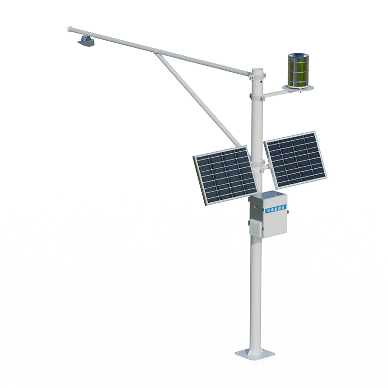
The integrated hydrological and water level monitoring device integrates water level, flow velocity, flow rate, and rainfall monitoring functions into a single device, primarily targeting automated monitoring of hydrological and water conservancy scenarios such as rivers, lakes, reservoir gates, and urban flooding. Based on K-band planar microstrip array radar technology, the sensor emits high-frequency electromagnetic waves towards the water surface. After receiving the reflected signals, it simultaneously calculates the water level and surface flow velocity. The built-in microprocessor then calculates the instantaneous cross-sectional flow and cumulative flow based on user-preset cross-sectional geometric parameters, completing the synchronous acquisition of four core hydrological parameters: water level, flow velocity, flow rate, and rainfall.
The non-contact measurement characteristics of the integrated water level and water condition monitoring device constitute a significant technological advantage. The radar probe is installed above the water body and fixed by existing structures such as brackets, bridges, or embankments, without direct contact with the water. Therefore, it is unaffected by sewage corrosion, siltation, and aquatic weed entanglement, maintaining stable measurement accuracy even during long-term operation in water bodies with high sediment content and high corrosiveness. The radar sensor employs a planar microstrip array antenna design, resulting in concentrated energy and low power consumption. The overall power consumption of the device is kept low, allowing it to be powered by solar panels and a battery pack, enabling long-term continuous operation in unattended field conditions. The device can independently connect to urban water, sewage, and environmental automatic monitoring systems, is compatible with the standard Modbus-RTU communication protocol, and uploads collected data to a backend monitoring platform via an RS485 digital interface or a 4G wireless module. Management personnel can view real-time trends in water level and flow velocity and receive abnormal alarm information on the platform.
In terms of structural design, this type of equipment adopts a highly integrated approach. Taking the portable hydrological emergency monitoring all-in-one device as an example, this product integrates a water level gauge, rain gauge, camera, and telemetry terminal into one compact and portable unit. On-site installation is quick and simple. The power supply system uses a high-performance lithium battery, providing 7 to 10 days of uninterrupted operation. In terms of communication, it supports GPRS/4G full network connectivity and dual-channel redundancy configuration with BeiDou satellite. When the primary communication network is interrupted, it automatically switches to the backup channel, solving the 36-hour communication blind spot problem after a natural disaster and ensuring stable transmission of hydrological information. Regarding monitoring accuracy, water level measurement accuracy can reach 0.2%FS, rainfall resolution can be as low as 0.1 mm, flow velocity measurement range is 0.1 to 20 m/s with a measurement accuracy of ±0.01 m/s, water level measurement range is 0 to 30 meters, and the radar's effective detection distance from the water surface can reach up to 40 meters.
From a practical application perspective, the hydrological and water level monitoring all-in-one device has been deployed on a large scale in river hydrological monitoring, irrigation area water measurement, urban drainage network monitoring, and emergency monitoring of sudden floods. In irrigation district water measurement scenarios, the equipment is installed at key sections of irrigation canals to monitor water levels and flow rates in real time. The data is uploaded to a water management platform for canal water allocation scheduling and water resource metering. In urban flood control, the equipment is deployed in underground stormwater networks or low-lying road sections to monitor water level changes in real time. When the water level reaches a preset warning value, it sends an early warning to the flood control command system, allowing for timely emergency response. During sudden rainstorms, floods, mudslides, or landslide-dammed lakes, portable monitoring devices can be quickly deployed to the site to establish temporary hydrological monitoring stations, providing real-time water level and rainfall data to the command center and supporting disaster relief decision-making.
Displacement monitor device utilizes harmless laser technology to accurately detect minute displacements in building structures such as walls and beams after disasters like earthquakes and explosions. By identifying even the slightest unstable movement, this equipment provides timely warnings...
I. Product IntroductionOur company is a professional manufacturer of meteorological sensors. We have been focusing on the research and development, as well as the production of various meteorological sensors, and also provide meteorological environment solutions. The company has a complete productio...
Total Phosphorus Analyzer employs the ammonium molybdate spectrophotometric method for the online or automated monitoring of total phosphorus content in water. It is applicable to the monitoring of surface water, municipal sewage, and industrial wastewater. Featuring a brand-new photoelectric...
Agricultural monitoring system provides precise guidance for agricultural production through comprehensive monitoring of soil moisture, crop growth, pest and disease infestations, and disasters.Soil Moisture Monitoring focuses on soil water status. Imbalances in soil moisture directly affect crop gr...


 Skype
Skype
 whatsapp
 mail
mail