Tianyi Sensor IOT Technology Co., Ltd
Sales Manager:Ms. Emily Wang
Cel,Whatsapp,Wechat:+86 15898932201
Email:info@fengtutec.com
Add:No. 155 Optoelectronic Industry Accelerator, Gaoxin District, Weifang, Shandong, China


Sales Manager:Ms. Emily Wang
Cel,Whatsapp,Wechat:+86 15898932201
Email:info@fengtutec.com
Add:No. 155 Optoelectronic Industry Accelerator, Gaoxin District, Weifang, Shandong, China
time:2025-12-19 11:18:20 source:Weather Station viewed:434 time
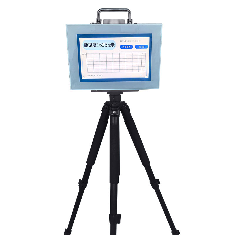
20km Portable Visibility Detector device employs the forward scattering method to calculate current atmospheric visibility by measuring the total extinction coefficient of the air. This equipment can be deployed on highways, mountain roads, and other similar locations to provide real-time visibility information, assisting traffic management departments in adjusting speed limits and issuing warnings. It is widely used in emergency response, road traffic, and meteorological monitoring.
20km Portable Visibility Detector is a field monitoring device specifically designed for measuring atmospheric visibility. Its core measurement principle is based on forward scattering. The physical basis of this method is that light is scattered when passing through an atmosphere filled with aerosol particles (such as fog, haze, rain, and snow). The instrument contains a light source emitter of a specific wavelength and a receiver located at a specific scattering angle (typically between 20° and 50°). The light emitted by the light source is scattered by airborne particles in the sampling area, and the intensity of the scattered light detected by the receiver is directly related to the concentration and size distribution of the airborne particles.
By measuring the intensity of this scattered light and combining it with a built-in algorithm model, the instrument can calculate the total extinction coefficient of the air. Meteorological optical range, or visibility value, has a defined mathematical relationship with the extinction coefficient. Therefore, the device can directly calculate and output real-time visibility values in meters or kilometers. Compared to traditional transmission methods, forward scattering offers advantages such as compact structure, no need for long baselines, and easy integration into portable devices.
Portability is key to the device's suitability for field deployment. The entire unit is typically integrated into a robust protective enclosure, containing optical measurement units, data processing modules, a power system, and communication units. The device supports battery power or solar-powered operation, enabling rapid installation and commissioning at monitoring points without the need for fixed observation stations. Its portability allows for flexible deployment to different critical road sections based on changing weather conditions or temporary monitoring needs.
The core application value of this detector lies in providing real-time data support for traffic safety management in low-visibility weather. In scenarios such as highways, mountain roads, cross-sea bridges, and airport connecting roads, sudden drops in visibility (such as fog) are one of the main risks leading to major traffic accidents. The equipment can monitor visibility changes in real time and transmit the data to a traffic monitoring center via a wireless network.
The monitoring center or local traffic control system automatically or manually activates corresponding management plans based on preset visibility thresholds. For example, when visibility drops to 500 meters, the system can issue speed limit warnings via variable message signs; when visibility further drops to 200 meters or lower, it can automatically activate the roadside fog collision avoidance guidance system, using flashing lights to outline the road for drivers; in extremely poor visibility conditions where safe driving cannot be guaranteed, the data can provide objective evidence for traffic management departments to decide whether to temporarily close dangerous road sections.
Besides road traffic management, this equipment is also widely used in other fields requiring visibility monitoring. In meteorological departments, it can supplement fixed observation network for emergency meteorological observation in the field or intensive monitoring of specific areas. In port and waterway management, visibility data is crucial for ship navigation safety. In the aviation field, it can be used for meteorological condition assessment around airports or at backup airports. Furthermore, it serves as a reliable tool for on-site visibility measurement in large-scale event security, environmental monitoring, and scientific research.
The normal operation and maintenance of the equipment must follow certain standards. The optical lens needs to be kept clean to prevent rain, dust, or insects from affecting measurement accuracy. Regular calibration using standard instruments is essential to ensure long-term data reliability and metrological traceability. When used in the field, attention must be paid to the physical safety of the equipment and the stability of the power supply.
In summary, the 20km Portable Visibility Detector is a precision optical measuring instrument based on the principle of forward scattering. It calculates visibility values in real time by measuring the intensity of atmospheric scattered light. Its portability allows for flexible deployment in various key traffic locations. The real-time, accurate visibility data it provides is a crucial input parameter for modern intelligent traffic management systems to issue warnings and respond to low-visibility weather conditions such as fog, directly contributing to improved road safety and operational management. It has practical application value in multiple industries, including emergency response, transportation, and meteorology.
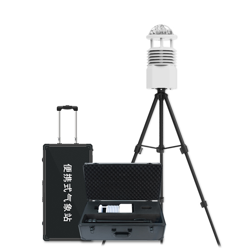
The Portable Weather Station is a professional device specifically designed for environmental monitoring. It is not only easy to install and operate with straightforward instructions but also delivers highly accurate measurement data. As a reliable observation system, it can simultaneously monitor m...
In the cold winter, transmission lines often face severe challenges of icing. When conditions such as low temperature, high humidity, and specific wind speed occur simultaneously, the phenomenon of icing on transmission lines is likely to form. Line icing not only increases the mechanical load on co...
In a tea plantation base, there is an Agricultural Weather Stations for the tea garden microclimate. Composed of devices such as cameras, digital displays, and smart agricultural monitoring sensors, it serves as the "smart brain" of the tea garden.The core, Agricultural Weather Stations, c...
Radar rain detector is a precipitation measurement instrument that uses 24GHz Doppler radar technology. It identifies rain, snow, and hail types and measures rainfall intensity by analyzing the falling velocity and particle size of precipitation particles. Unaffected by foliage cover, it offers sensitive and rapid detection and is widely used in meteorology, hydrology, environmental protection, and flood control....


 Skype
Skype
 whatsapp
 mail
mail